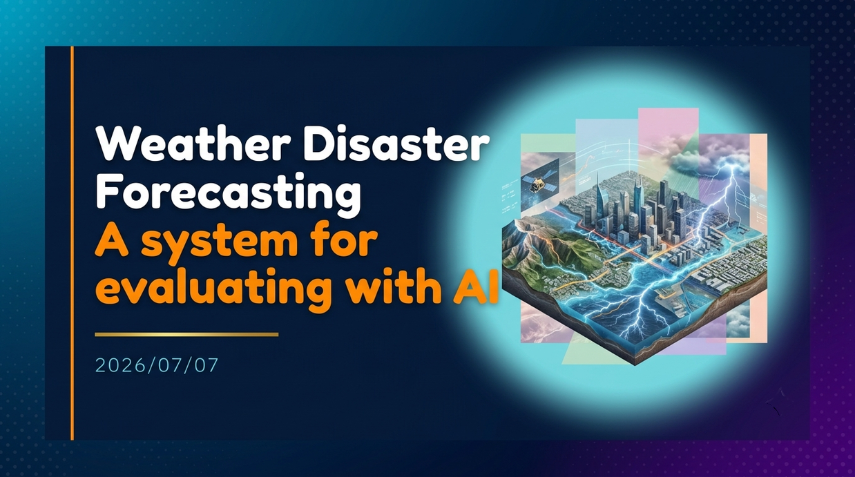
Space Data Inc. has launched the “Storm Simulator,” which uses AI to predict and evaluate damage from weather disasters. Behind this is the intensification of disasters caused by global warming and a strong social need for intuitive risk assessment, which was difficult with conventional flat hazard maps.
- Key points of service launch and quantitative damage assessment
- Power outage prediction with the new feature “Thunder & Blackout”
- Challenges Faced by Traditional Hazard Maps
- 3D reproduction using satellite data and real-world data
- Speed and scalability of wide-area processing
- Corporate decision-making and adaptation to climate change
- Expansion and Global Deployment of Disaster Response
Key points of service launch and quantitative damage assessment
Space Data Inc. (Head Office: Minato-ku, Tokyo; President & CEO: Koyo Sato) announced on July 1, 2026, that it released the meteorological disaster risk assessment AI “Storm Simulator” as a new feature in the resilience domain “Geo-Resilience” of the space AI platform “SpaceBrain.” This system targets organizations engaged in disaster prevention and crisis management, such as governments, local governments, and infrastructure operators. Its greatest feature is that the impact of weather disasters such as typhoons, heavy rains, and floods can be quantitatively evaluated using the following three indicators.
-
People at Risk
-
Assets at Risk such as affected buildings and infrastructure
-
Expected Economic Loss
Whereas until now, flooding at specific locations was often checked, this system presents specific numerical figures indicating “who, what, and how much” is affected. This enables companies and municipalities to make quick and accurate decisions.
Power outage prediction with the new feature “Thunder & Blackout”
On July 2, 2026, a new feature called “Thunder & Blackout” was added to simulate power outage damage caused by lightning strikes. Lightning strikes directly impact transmission and distribution facilities or induced lightning can cause sudden power outages even in urban areas, resulting in cascading damages to social functions such as transportation, communications, and healthcare. This feature estimates and visualizes the following information in three dimensions using the lightning strike occurrence point (location, current) as a starting point on a 3D city model.
-
Areas where blackouts are spreading
-
Number of Affected Households and Population
-
Estimated Time to Recovery
The scale of blackouts is shown in four stages, from partial outages at Lv1 to large-scale outages at Lv4. Furthermore, based on the magnitude of the lightning current (kA), it is possible to calculate the outage radius and affected area. In simulations, lightning strikes, lightning strikes, and darkening of buildings within blackout areas are reproduced, and combined with time-series graphs, you can intuitively and overlook the extent of damage.
Challenges Faced by Traditional Hazard Maps
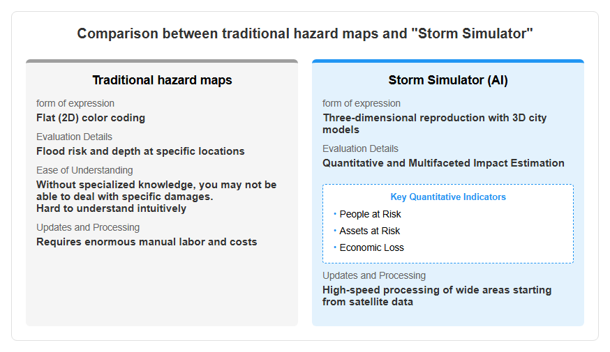
Behind this development is a sense of crisis over water disasters that are becoming more severe due to climate change. During the 2019 Reiwa 1st Year East Japan Typhoon (Typhoon No. 19), the Tama River overflowed, causing severe flooding damage even in urban areas. However, conventional damage assumptions and hazard maps mainly used flat representations, making it difficult for general users and company representatives to intuitively understand “which building and how deep the water is approaching.” Additionally, quickly grasping wide-area damage conditions required enormous manual effort and cost, and delays in real-time response became a major challenge. To resolve these “difficulty in visibility of information” and “delays in grasping,” it was necessary to build an environment where even non-experts could immediately share images of the damage and lead to concrete preparedness. Please refer to the diagram below.
Advanced Simulation Supported by Digital Twins
3D reproduction using satellite data and real-world data
The technical foundation of “Storm Simulator” lies in satellite data analysis technology, which is a strength of space data, and global digital twin technology. The system integrates the following public real-world data:
-
Numerical elevation model from the Geospatial Information Authority of Japan (approximately 10m mesh terrain data)
-
Building shapes based on the Ministry of Land, Infrastructure, Transport and Tourism’s 3D city model “PLATEAU”
-
Population distribution data and flood performance data
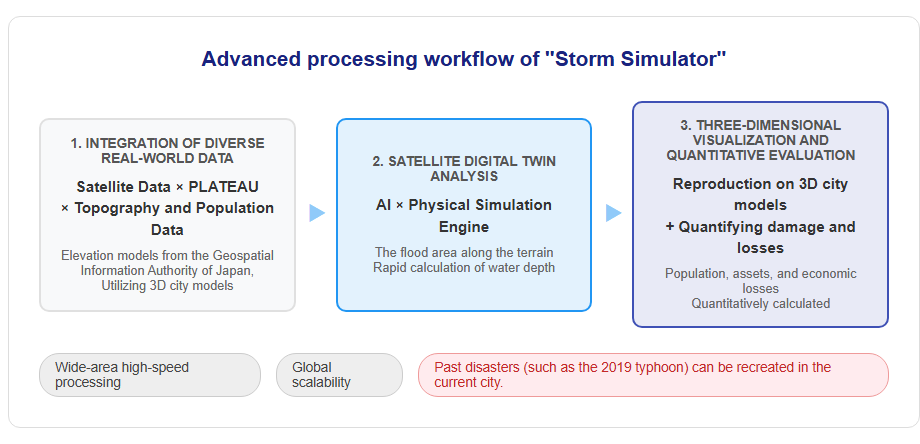
By combining this data with AI and physical simulations, it precisely calculates where and how much water accumulates along the terrain. The simulation results are reproduced on a 3D city model, representing water depth with color gradations. Because the water approaching buildings is depicted in three dimensions, users can intuitively understand the scale of damage as if it were a real cityscape.
Speed and scalability of wide-area processing
This system is equipped with the capability to rapidly process damage predictions over a wide range by starting from satellite data. It is characterized by high scalability, allowing expansion beyond specific cities to various regions both domestically and internationally. For example, it is possible to recreate large-scale disasters such as the flooding of the Tama River during the 2019 East Japan Typhoon and the 2000 Tokai heavy rains onto the current cityscape. Currently, some parts use simple estimation models based on sample data, but going forward, further improvements in prediction accuracy are planned by deepening integration with actual data such as power grids and lightning observations. By using satellite digital twin technology, damage assessment at a speed that was impossible with conventional manual analysis has been achieved. Please refer to the diagram below.
Social Implementation and Future Prospects
Corporate decision-making and adaptation to climate change
“Storm Simulator” is expected to serve not only as a disaster prevention tool but also as an infrastructure supporting corporate business strategies. In recent years, companies have been required to disclose the risks and opportunities brought by climate change (such as TCFD and TNFD). Quantitative and multidimensional damage assessments using AI provide strong evidence for understanding flood risks at your own sites and for assessing supply chain vulnerabilities. Additionally, in the non-life insurance industry, there is a growing need for designing AI-based parametric insurance (a system that pays out claims based on predetermined indicators) and for calculating premiums based on more precise risk assessments. Space Data establishes the foundation of “Geo-Resilience,” providing an integrated process from forecasting and damage assessment to early warning and decision support, aiming to enhance society’s resilience.
Expansion and Global Deployment of Disaster Response
Looking ahead, Space Data plans to significantly expand the scope of “Storm Simulator.” In addition to current typhoons, heavy rains, floods, and lightning, we will expand our response to all types of weather disasters such as storms, hail, and tornadoes. Furthermore, in the long term, the policy is to develop a comprehensive foundation for disaster risk assessment that covers landslides, wildfires, tsunamis, and climate change adaptation. International initiatives are accelerating, and in collaboration with the international framework “Space4Resilience,” jointly established with the United Nations Space Department (UNOOSA) and the Commonwealth Office, we aim to deploy Japan’s satellite digital twin technology to disaster-risk regions worldwide. Through this, the fusion of space technology and digital technology will contribute to global disaster reduction and the realization of a sustainable society.
[#スペースデータ #StormSimulator #デジタルツイン #防災減災 #気象災害 #AI #PLATEAU]


コメント