Construction work is steadily progressing in Numazu City, Shizuoka Prefecture, for the “Numagawa New Diversion Channel Improvement Project,” one of the prefecture’s largest river projects aimed at preventing flood damage. The background involves the frequent occurrence of record-breaking heavy rains due to climate change and the chronic risk of inland flooding stemming from the unique topography of the Ukishima lowland.
- Key Points of Events and Latest Site Conditions for the Numagawa New Floodway Project
- The Complete Overview of the 2.3 km Construction Structure and Multi-Agency Collaboration
- Inland Flooding Caused by Ship-Bottom-Shaped Topography and Memories of Heavy Rain Disasters
- Advancing the Action Plan and Countering Increasingly Severe Heavy Rain
- Significant Cost Reduction through Recycling Construction Surplus Soil
- Timeline to Complete Completion, Future Outlook, and Key Points to Watch
Key Points of Events and Latest Site Conditions for the Numagawa New Floodway Project
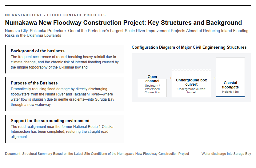
In the western part of Numazu City, Shizuoka Prefecture, the “Numagawa New Diversion Channel Construction Project,” one of the largest flood control measures in the prefecture aimed at protecting the region from heavy rain disasters, is steadily progressing. This project is a large-scale river improvement initiative designed to directly discharge floodwaters from the east-west flowing Numagawa and Takahashi rivers into Suruga Bay via a new artificial waterway. At the construction site, the installation of large-scale civil engineering structures is in full swing, including a massive underground culvert tunnel currently under construction and a gigantic 13-meter-high floodgate to be installed in the coastal area. The interior of the underground tunnel is a space that will be completely inaccessible to the general public once water flows through it in the future, marking a valuable construction phase prior to the flow of water. The main events and current status at the site are as follows.
- Project Objective: Dramatically reduce flood damage in the Numa River basin, where a gentle gradient impedes water flow.
- Main structures: Open channels, underground box culverts, 13m-high coastal floodgates.
- On-site progress: Box structure construction and main sluice gate work are underway inside the underground tunnel prior to water flow.
- Roadside Traffic Measures: Road diversion near the former National Route 1 Otsuka Intersection has been completed, restoring a straight alignment.
Additionally, steady work continues around the construction site while ensuring safe passage. Please refer to the photos below.
The Complete Overview of the 2.3 km Construction Structure and Multi-Agency Collaboration
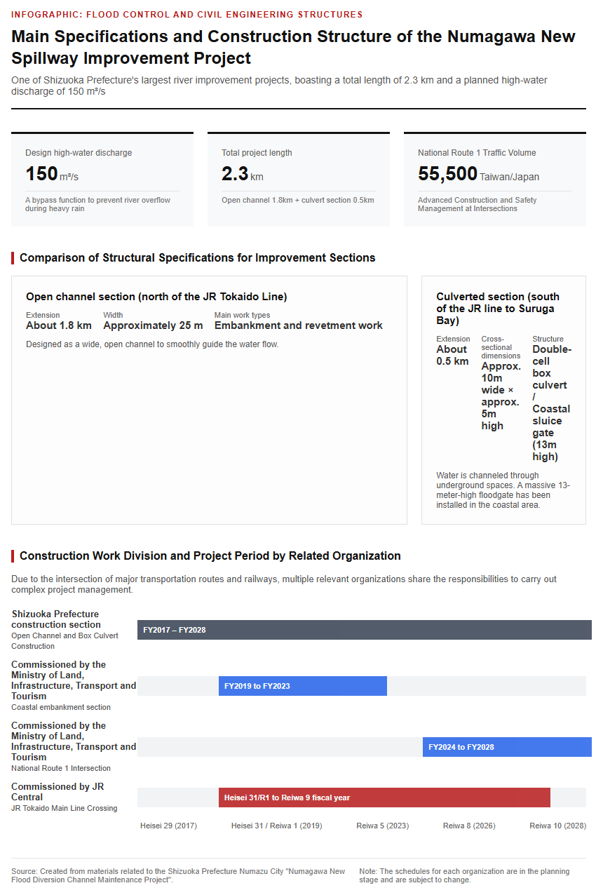
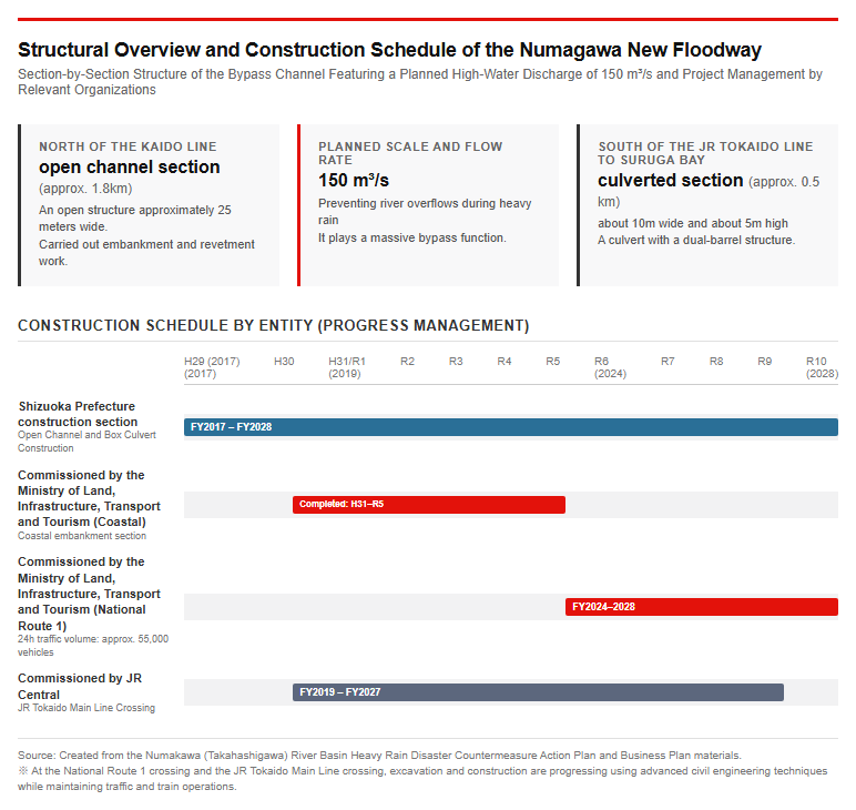
The Numagawa New Diversion Channel is planned to have a total length of approximately 2.3 km, and construction is progressing by dividing it broadly into two sections. The area north of the JR Tokaido Line is an open “open-channel section” (approximately 1.8 km) with a width of about 25 m, where embankment and revetment works are being carried out. Meanwhile, the section from south of the JR Tokaido Line to Suruga Bay will be developed as a “culvert section” (approximately 0.5 km) featuring a dual-box structure with a width of about 10 m and a height of about 5 m. The planned high-water discharge for this project reaches 150 cubic meters per second (150 m3/s), playing a massive bypass role to prevent river overflow during heavy rainfall.
Because this construction project intersects with major arterial roads and railways, it involves complex schedule management, with multiple related organizations sharing responsibility for commissioning and executing the work.
- Shizuoka Prefecture Construction Section: Box culvert work for open channels and underground conduits (FY2017–FY2028)
- Sections commissioned by the Ministry of Land, Infrastructure, Transport and Tourism: Coastal levee section (completed from FY2019 to FY2023) and National Route 1 crossing section (FY2024 to FY2028)
- JR Central Commissioned Section: JR Tokaido Main Line Intersection (FY2019 [Heisei 31 / Reiwa 1] – FY2027)
Extremely advanced civil engineering technologies and safety measures are being deployed, particularly for the construction work to tunnel beneath Route 1—which has a 24-hour traffic volume of approximately 55,500 vehicles—and the JR Tokaido Main Line, where train operations cannot be halted. Please refer to the figure below.
Topographical Challenges and the History of Flood Damage in the Ukishima Lowland
Inland Flooding Caused by Ship-Bottom-Shaped Topography and Memories of Heavy Rain Disasters
The Numagawa River basin is a Class A river system with a basin area of 206 square kilometers and a channel length of approximately 14.1 km, originating at the foot of Mt. Ashitaka and flowing into Tagonoura Port in Suruga Bay. It flows westward while being joined by tributaries such as the Takahashi River (basin area of 23 square kilometers, channel length of approximately 6 km). The greatest geographical feature of this basin is that it is located in a ship-bottom-shaped lowland area (approximately 14 km east-west and 1 to 2 km north-south) called the “Ukishima Lowland,” which is sandwiched between the Ashitaka volcanic terrain to the north and the gravel bar to the south. The Numagawa River flows along the southern edge of this lowland at an extremely gentle gradient of 1/1,000 to 1/4,000, and during heavy rainfall, the drainage of internal water is hindered, leading to frequent flood damage.
The records of major past floods in the region are as follows:
- September 1958 (Kanogawa Typhoon): Severe damage occurred in the downstream area, resulting in 609 deaths and missing persons and 2,679 houses flooded above floor level.
- July 1974 (Tanabata Flood): Extensive internal flooding occurred in the Numagawa river basin, serving as the catalyst for drafting the flood relief channel project.
- 1986 and 1990: Evolution from the Takahashi River Floodway Project to the Numagawa New Floodway Survey and Planning
Thus, coupled with topographical conditions that hinder drainage and the advancement of urbanization, the construction of a discharge channel became essential as a fundamental flood control measure.
Advancing the Action Plan and Countering Increasingly Severe Heavy Rain
In response to repeated flood damage, Shizuoka Prefecture and Numazu City formulated the “Numagawa (Takahashigawa) River Basin Heavy Rain Disaster Countermeasure Action Plan” in March 2008, embarking on basin-wide flood control measures. In addition to structural measures such as the installation of rainwater storage basins in upstream areas and river channel excavation, they comprehensively implemented non-structural measures such as distributing hazard maps and providing water level information. These efforts successfully reduced the number of houses flooded above floor level to one-fifth of previous levels during Typhoon No. 18 in October 2014.
However, in recent years, unprecedented torrential rains associated with climate change have occurred one after another, causing new damage.
- July 2021 Torrential Rain: The Numagawa River basin recorded an average rainfall of 373.9 mm (significantly exceeding the planned rainfall of 301.6 mm), resulting in extensive damage, including 166 houses flooded above floor level and 128 houses flooded below floor level in areas such as the Aono and Nishizoe districts.
- June 2023 Typhoon No. 2: Recorded damage of 98 houses flooded above floor level and 67 houses flooded below floor level due to heavy rainfall with a total precipitation of 489 mm
Localized measures alone, such as rainwater retention basins and additional pumps, have their limits, and there is a growing local demand for the early completion of the Numagawa New Discharge Channel to rapidly discharge water from the entire basin into the sea. Please refer to the figure below.
Technical Innovation and Future Completion Outlook
Significant Cost Reduction through Recycling Construction Surplus Soil
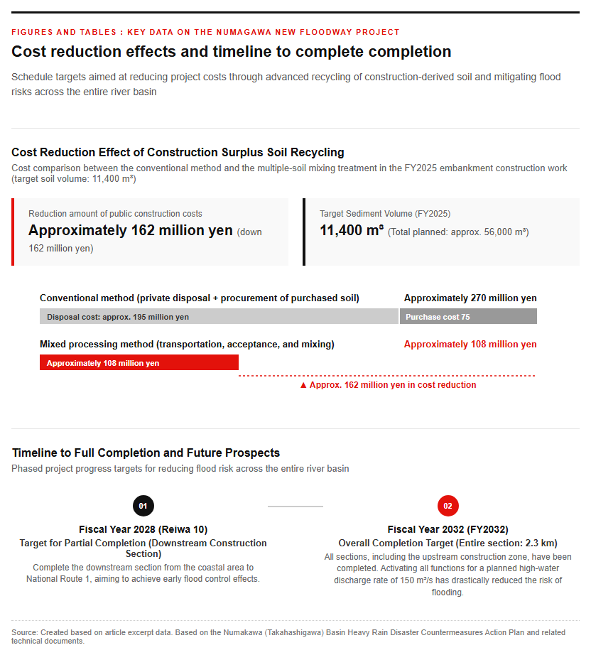
At the construction site of the Numagawa New Spillway, advanced civil engineering technologies that achieve both a reduction in environmental impact and lower project costs have been introduced. Following the enforcement of the prefectural embankment ordinance in July 2022 and the Embankment Control Law in May 2023, soaring acceptance costs for surplus soil from construction and a shortage of disposal sites had become serious issues within the prefecture. In response, the Shizuoka Prefectural Numazu Civil Engineering Office worked to effectively utilize surplus soil hauled out from other construction projects for the embankment construction work of approximately 56,000 cubic meters planned for the open-channel section of the spillway.
For gravelly soil and volcanic ash cohesive soil, which are individually unsuitable for embankment construction in terms of cohesiveness and particle size distribution, we have established a method to mix and process multiple types of generated soil at an optimal ratio based on detailed soil tests.
- Target soil volume: A total of 11,400 cubic meters of mixed soil adopted as embankment material in the FY2025 embankment construction work.
- Cost of the conventional method: When outsourcing disposal to the private sector and procuring purchased soil, disposal cost of approximately 195 million yen + procurement cost of approximately 75 million yen = approximately 270 million yen
- Mixing treatment cost: The cost required for transportation, acceptance, and mixing treatment was approximately 108 million yen.
- Reduction Effect: Achieved a reduction in public works costs of approximately 162 million yen (approx. 162 million yen) as the difference.
This initiative has been highly praised as a model case that achieves both resource recycling and cost reduction in public construction projects.
Timeline to Complete Completion, Future Outlook, and Key Points to Watch
The Numakawa New Floodway Construction Project is progressing with the aim of phased completion and commencement of operation to ensure the safety of local residents’ daily lives. The key timeline currently proposed and future outlook are as follows.
- Partial completion target (FY2028 / 2028): Complete the downstream construction section (downstream section) from the coastal area to National Route 1, aiming to achieve early flood control benefits.
- Overall completion target (FY2032 / FY 2032): Complete the entire section (2.3 km) including the upstream construction section, and put all functions for the planned high-water discharge rate of 150 m3/s into operation.
Points to watch going forward include advanced construction management in special sections intersecting with operating railways and arterial roads, handling the reduction of on-site work yards as the project progresses, and securing planned stockyards for surplus soil generated by other projects. Once the massive floodgates at the intersections of the floodway and coastal levee are completed, the long-standing risk of flooding across the entire area from the western district of Numazu City to the Ukishima lowland will be dramatically reduced. As a paramount project that will significantly alter the future landscape of regional infrastructure, high expectations are placed on its future progress. Please refer to the photos below.
Reference Page
- 【Kano River Typhoon, September 26, 1958 (Showa 33) – Chubu Disaster Archives】http://www.cck-chubusaigai.jp/kinnen_saigai/19580926.html
[#NumakawaNewFloodDiversionChannel #ShizuokaPrefecture #NumazuCity #FloodControl #DisasterPrevention #CivilEngineering #InternalFlooding]


コメント