Informatics Inc. and the Ministry of Land, Infrastructure, Transport and Tourism have developed and released a “Spatial Information MCP Server” that connects GIS (Geospatial Information System) with generative AI. Behind this is the growing need to make geospatial information—which previously required specialized operation—intuitively accessible to everyone using natural language.
- Announcement of new technologies connecting generative AI and GIS
- The Role of MCP (Model Context Protocol)
- Pioneering Initiatives by the Ministry of Land, Infrastructure, Transport and Tourism
- How to Search and Retrieve Data Using Natural Language
- Comparison and advantages with existing GIS operations
- Advanced integration with real estate information libraries
- Security Risks Unique to MCP Servers
- Measures and guidelines for safe operation
- Impact on municipal DX and smart cities
- Progress and Key Points of Automation by AI Agents
Announcement of new technologies connecting generative AI and GIS
In the utilization of geospatial information, the development of the “Spatial Information MCP Server” announced by Informatics Inc. on June 25, 2026, marks a major turning point in the field of science and technology. This server enables generative AIs like ChatGPT and Claude to automate the entire process of searching and retrieving GIS data, as well as creating documentation, using only natural language instructions. The development was driven by the recent spread of open data by local governments, but until now, it required tedious manual tasks such as searching for necessary information on maps, transcribing numbers, and capturing images. This newly developed system has been launched for “GC Navi,” a public GIS system for local governments. Even users unfamiliar with IT can simply enter “Summarize evacuation center information around designated locations” on the chat screen, and AI will handle everything from location identification to creating a list. Since its founding in 1981, Informatics has supported DX through spatial information technology, and with the provision of the MCP server, it aims to improve operational efficiency beyond the framework of GIS.
The Role of MCP (Model Context Protocol)
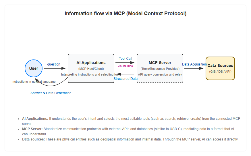
The “MCP (Model Context Protocol),” which forms the core of spatial information MCP servers, is an open communication standard for connecting generative AI with external tools and data sources. Released by Anthropic in November 2024, it quickly established itself as an industry standard following announcements from OpenAI, Google, and others to support it. Traditional generative AI excelled at answers based on learned knowledge, but lacked direct access to the latest geographic information or internal databases. When developers implemented APIs individually, the “N×M problem” occurred, where development costs increased as the number of partners increased. MCP resolved this issue by adopting a common standard like “USB-C for AI.” By building an MCP server, its functions become accessible from any corresponding AI application, making its introduction extremely beneficial for systems handling highly specialized data such as geospatial information. The following diagram shows the flow of information via MCP.
Pioneering Initiatives by the Ministry of Land, Infrastructure, Transport and Tourism
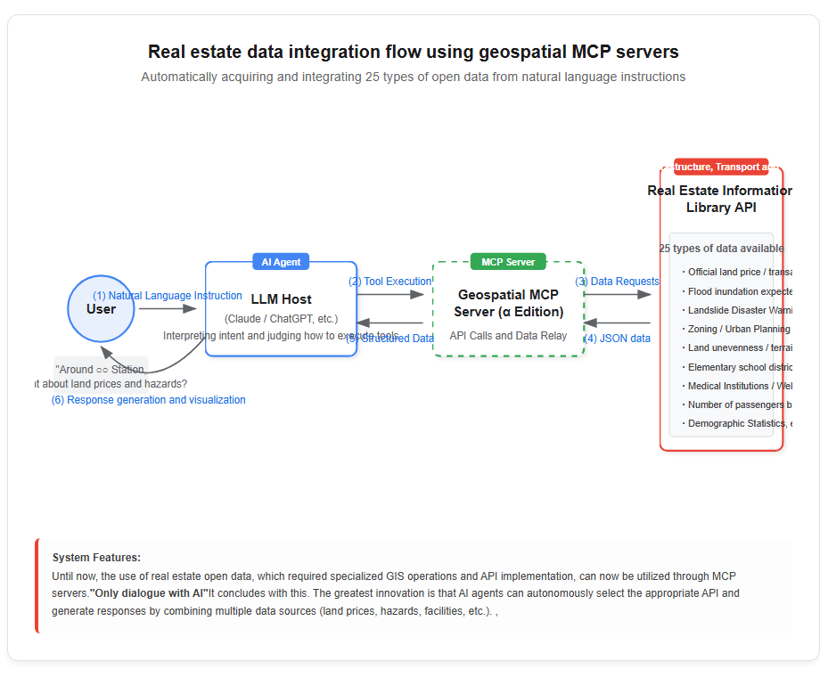
The use of MCP is accelerating at the government level as well, and the Ministry of Land, Infrastructure, Transport and Tourism released the “Geospatial MCP Server (α Version) on February 26, 2026.” This allows 25 types of open data provided by the department’s “Real Estate Information Library” to be directly accessed from LLMs and AI agents. Since launching the Real Estate Information Library in April 2024, demand has increased to record about 18 million page views in one year, providing data such as land price announcements and flood inundation assumption areas through APIs. However, mastering these APIs required GIS expertise, which posed a development barrier. By prototyping and providing the MCP server by the Ministry of Land, Infrastructure, Transport and Tourism, an environment has been established where AI can automatically select appropriate APIs and generate responses to natural language questions such as “Researching land prices and zoning around a specific building.” This move is part of the government’s “DX in Architecture and Urban” roadmap, positioned as an important infrastructure development with an eye toward creating new services beyond 2028.
Technological Innovation in GIS Utilization Brought by MCP
How to Search and Retrieve Data Using Natural Language
The introduction of MCP servers has dramatically changed the process of searching geospatial information. When a user asks the AI, “Please tell me the official land prices and nearby medical institutions around XX Station,” the AI automatically recognizes the definitions of tools provided by the MCP server and assembles queries to obtain the necessary data. Internally, communication is carried out through standardized messages in JSON-RPC format, and secure handshakes are executed between the AI host and the MCP server. The acquired structured data is restructured by AI into natural text or table formats and presented to users. Notably, AI is now autonomously making decisions about “which datasets are needed,” which were previously made by humans, but now AI is autonomously making “agentization.” This made it possible to obtain advanced spatial analysis results through dialogue alone, without going through the GIS control screen. Data accuracy has also been improved compared to traditional function calls through the introduction of declarative interfaces.
Comparison and advantages with existing GIS operations
Traditional GIS utilization, especially using industry-standard tools like ArcGIS, required advanced expertise and licensing fees to master desktop applications and dedicated web services. On the other hand, spatial information MCP servers open the door for anyone to utilize geospatial information as long as there is a chat interface on a web browser. Comparing the roles of Informatics Inc.’s “AI chat function” and “MCP server,” the former supports operations on GIS screens, while the latter automates document creation beyond the GIS framework. Additionally, on the development side, since it is an open protocol independent of any particular vendor, interoperability with diverse solutions such as Google Cloud and existing open-source software like QGIS is expected to improve. The ability to update data in real time in a cloud-native environment is also a major advantage not found in conventional installable software.
Advanced integration with real estate information libraries
The Ministry of Land, Infrastructure, Transport and Tourism’s geospatial MCP server enables integration with a wide range of data held by the real estate information library. The 25 types of data that can be obtained include not only land price information and transaction prices, but also terrain information such as hazard maps (floods and landslides), urban planning areas, land relief, and even statistics like passenger numbers by station and demographics. Until now, combining these data required complex operations by layering different layers, but with the MCP server, complex tasks such as “checking shelter information on a map and compiling it into a table” can be executed all at once. Scenarios for use include automating property proposals by real estate companies and supporting site selection for new store launch sites. For example, based on the customer’s desired school district and hazard risk conditions, AI can extract the optimal property in real time and present the data as the basis. Such data bridging capabilities are becoming a source of competitiveness in the PropTech sector. Please refer to the diagram below for the actual operation flow.
Challenges and Security of Spatial Information MCP Servers
Security Risks Unique to MCP Servers
While MCPs offer strong convenience, serious security risks stemming from their structure have also been pointed out. One particularly concerning attack method is called “Tool Poisoning.” This involves rewriting the tool descriptions provided by the MCP server to AI with malicious content to manipulate the behavior of the LLM. Since tool descriptions are injected directly into the LLM’s context window, embedding hidden commands carries the risk that AI may unintentionally transfer or delete data. According to a survey conducted in March 2026, about 66% of publicly available MCP servers have been detected with some form of security issue, some of which have insufficient authentication or encryption. AI agents operate 24/7 without human-like judgment or time constraints, so once an incident occurs, the scale of damage risks affecting the entire company.
Measures and guidelines for safe operation
Experts recommend thoroughly adhering to the “principle of least authority” regarding these risks. For AI agents, it is important not to abuse existing users’ privileges as is, but to grant dedicated accounts with access restrictions to specific directories or repositories. Additionally, companies like Informatics and Workato have recommended implementing multi-layered validation. Specifically, it is desirable to perform verification at least three stages: when receiving user input, before the model calls external tools, and before running the MCP server. Additionally, when publishing MCP servers over the network, communication encryption via TLS is mandatory, and a system must be established to regularly monitor execution logs to check for unexpected behavior. Security should not be added later, but should be built into the design stage, and in the era of AI agents, the introduction of MCP servers requires rigorous reviews equal to or greater than those for adding npm packages.
The Future and Future Outlook of Geospatial Information
Impact on municipal DX and smart cities
The widespread adoption of spatial information MCP servers is a driving force accelerating digital transformation (DX) in municipalities. As of 2026, the informatics system “GC Navi” has been introduced in 38 municipalities nationwide, functioning as a data dissemination platform for disaster prevention and urban planning. In smart city concepts, it is essential to centrally manage the vast real-time data obtained from sensors installed throughout the city on a map, enabling rapid decision-making. Through the MCP server, AI can instantly analyze traffic congestion information and water level data, enabling advanced operations such as issuing optimal traffic control and evacuation guidance instructions. The Ministry of Land, Infrastructure, Transport and Tourism has also included expanding integration with the 3D city model “PLATEAU” and Real Estate ID in its roadmap, aiming for a society where anyone can conduct detailed simulations at the building level. Such public infrastructure development is expected to boost service creation by private companies and greatly contribute to improving overall social efficiency.
Progress and Key Points of Automation by AI Agents
The future focus is on the process of AI evolving from a mere “search tool” into a “complete agent” that autonomously performs its tasks. As the scope of MCP servers expands, AI will accomplish not only geographic information acquisition but also the creation of reports based on the results, messages to relevant departments, and even the operation of IoT devices on site. Expanding generative AI capabilities will fundamentally improve information search and processing capabilities, eliminating the need for humans to manually navigate multiple SaaS services. On the other hand, there is a current situation where legal issues, terms of use, and security policies have not kept pace with the rapid technological advancement. Going forward, the focus of discussion will be on the legal responsibility for data theft by malicious MCP servers and how to ensure the difference in reliability between official and unofficial servers. Now that geospatial information has gained new wings through AI, the next challenge is how to build a healthy ecosystem while weighing convenience and risk.
[#空間情報 #MCP #生成AI #自治体DX #GIS #地理空間情報 #国土交通省 #セキュリティ]


コメント