Starting August 29, 2026, record-breaking heavy rain occurred in Fukui Prefecture, and overflow and inland flooding were confirmed in multiple rivers, including the Yoshino River flowing through Fukui City. This heavy rain disaster has highlighted challenges not only regarding the region’s living infrastructure, but also in securing commuting means within corporate Business Continuity Plans (BCPs).
- Issuance of Level 5 Heavy Rain Special Warning and Weather Overview
- The Reality of Overflow and Inland Flooding of the Yoshino River and Damage to Residential Properties
- Tense flood control operations at Ryuganohana Dam and other locations
- Improvement plan for the confluence of the Kuzuryu River and the Yoshino River
- The Blind Spot of Losing Your Means of Commuting Due to a Submerged Personal Vehicle
- Development of Alternative Transportation in Suburban Areas and Future Focus Areas
Issuance of Level 5 Heavy Rain Special Warning and Weather Overview
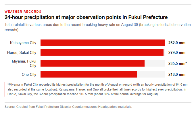
From the night of August 29, Reiwa 8 (2026), warm and humid air flowed toward a stationary autumn rain front over Honshu, subjecting Fukui Prefecture to unprecedented heavy rainfall. At 5:30 a.m. on August 30, the Japan Meteorological Agency issued a Heavy Rain Special Warning—Hazard Level 5—for three cities: Fukui, Ono, and Katsuyama. In response to the situation, the Fukui Prefectural Disaster Response Headquarters was established at 4:30 a.m. on August 30, raising the alert level to maximum to handle the emergency. The intensity of the heavy rain was fierce; Sakai City’s Harue recorded 116.5 millimeters of rainfall over a three-hour period, setting an all-time record for the location. This is an amount equivalent to about 80% of the normal August precipitation in just a few hours. For 24-hour rainfall, Katsuyama recorded 282.0 millimeters, Harue in Sakai City recorded 279.0 millimeters, and Ono recorded 218.0 millimeters, breaking all-time records across various locations. Additionally, Miyama in Fukui City recorded 24-hour rainfall of 235.5 millimeters and hourly rainfall of 64.0 millimeters, resulting in a torrential downpour that broke records for the month of August.
The Reality of Overflow and Inland Flooding of the Yoshino River and Damage to Residential Properties
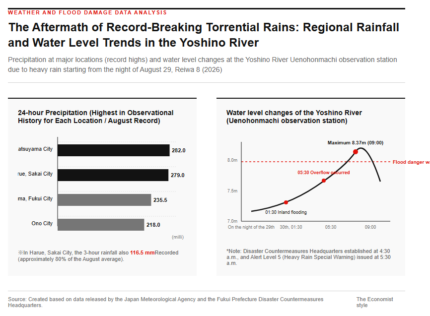
The record-breaking heavy rain caused flooding and overflow in many rivers throughout Fukui Prefecture. Particularly along the Yoshino River of the Kuzuryu River system, internal flooding occurred in Uenohonmachi, Fukui City, at 1:30 a.m. on August 30, resulting in inundated roads. Although emergency drainage work using pumps was underway at the site, overflow also occurred along the Yoshino River in Furuichi 3-chome, Fukui City, at 5:30 a.m. on the same day, confirming severe road inundation and under-floor inundation of residences. At the Uenohonmachi observation station on the Yoshino River, the water level greatly exceeded the flood danger level of 8.08 m, reaching a peak of 8.37 m at 9:00 a.m. The following image illustrates the heightened risk of river flooding due to the heavy rain at the time.
Additionally, on the Arakawa River—which is also part of the Kuzuryu River system—agricultural land was flooded due to overflow in Haramedi-cho, Fukui City, at 5:09 a.m. on August 30, and successive overflows and road inundations occurred along the Ebata River, Sogui River, Tajima River, and others. According to data compiled by the Fukui Prefecture Disaster Countermeasures Headquarters, as of 12:00 p.m. on August 30, residential damage had been reported, including 1 home flooded above the floor and 15 homes flooded below the floor, while investigations into further inundation and flooding damage proceeded in areas such as the Hanyu district in Fukui City and around Kunigami Shrine in Sakai City.
Flood Control Measures in Dam Management and River Improvement
Tense flood control operations at Ryuganohana Dam and other locations
To curb rising river water levels, multiple dams across Fukui Prefecture simultaneously initiated emergency flood control operations. Flood control measures were carried out sequentially at the Tatsuganohana Dam in Sakai City starting at 7:36 PM on August 29, at the Jodojigawa Dam in Katsuyama City at 9:00 PM on the same day, and at the Eiheiji Dam in Eiheiji Town at 3:55 AM on August 30. Notably, at the Tatsuganohana Dam in the upper reaches of the Takeda River, the water storage level rose rapidly and threatened to exceed the flood control capacity, leading to the announcement of a potential shift to emergency discharge and urging residents in the basin to maintain the highest level of vigilance. To respond to this tense situation, local governments promptly issued evacuation information. Emergency Safety Assurances were temporarily issued for the entire cities of Fukui, Ono, and Katsuyama, affecting a total of 128,321 households and 302,610 people across the three cities. Furthermore, when including those subject to evacuation orders and evacuation orders for the elderly and others, the number of evacuation targets reached 159,234 households and 387,899 people across the entire prefecture, with 115 designated evacuation shelters opened where many residents took refuge.
Improvement plan for the confluence of the Kuzuryu River and the Yoshino River
The Yoshino River, which was recently exposed to the risk of severe flooding, is a low-lying river with a length of approximately 3.5 km that flows into the Kuzuryu River. The downstream area of the Yoshino River basin is close to JR Morita Station and has in recent years developed into a commuter town with ongoing residential development. However, the Yoshino River is extremely narrow, with a width of only about 8 m in the downstream 1.6 km section, and less than 4 m in the upstream area. Consequently, it suffered from a fatal vulnerability: its flow capacity—which indicates the amount of water it can convey—was extremely low at less than 10 cubic meters per second in the densely populated downstream section. Inundation damage also occurred during the heavy rains caused by the rainy season front in July 1981, making flood control measures a long-standing challenge. The following figure shows an overview of the improvement plan for the Yoshino River basin.
Currently, in coordination with the Fukui City Land Readjustment Project, a flood control plan with an exceedance probability of once every 50 years—designed to withstand torrential rainfall that occurs once every half-century—has been formulated, and work is underway on the 3.475 km stretch upstream from the confluence of the Kuzuryu River. The upstream section is planned to be handled by excavating the New Shin-kawa River. Once the improvements progress, approximately 750 houses and two schools located within the 140-hectare area can be protected from the threat of heavy rainfall, so early completion is strongly desired.
The Impact of Disasters on Corporate Activities and New BCP Strategies
The Blind Spot of Losing Your Means of Commuting Due to a Submerged Personal Vehicle
Heavy rain and flooding inflict serious, often overlooked impacts not only on physical infrastructure such as houses and roads, but also on corporate business continuity. In recent years, a blind spot has emerged in many factories and offices where employees cannot commute—even when facilities and buildings remain undamaged—due to the loss of transportation means. This issue is particularly prominent in suburban factories and regional business sites where public transportation options are limited and commuting by private car is the norm.
Private cars owned by employees are highly efficient means of transportation during normal times, but when they are simultaneously submerged and destroyed by flooding, it shakes the foundations of corporate business continuity. In other words, while cars are personal assets, they also function practically as decentralized transportation infrastructure supporting corporate operations. Even if safety confirmation systems verify that employees and their families are safe, they cannot reach the workplace if they have lost their cars. There is a need for practical planning that goes beyond measures against the disaster itself and addresses the resulting deficit in management resources: the inability of necessary employees to reach the workplace.
Development of Alternative Transportation in Suburban Areas and Future Focus Areas
The question of how far companies should go in supporting employees who have lost their means of commuting is extremely delicate. Since private vehicles are personal assets, companies directly bearing the costs of repair or replacement should be approached with caution from the perspective of ensuring fairness and financial prudence. However, with the aim of an early resumption of operations, it is realistic to frame the support not as the vehicle itself, but as providing alternative functionality to travel to the workplace. Specific alternative measures could include temporary subsidies for taxi or rental car usage fees, operating shuttle buses from the nearest station or temporary parking lots outside flooded areas to the business premises, and establishing carpooling systems among employees living in the same area. Furthermore, securing temporary accommodation near factories for safety management personnel holding critical qualifications is also effective. In Fukui Prefecture, for small and medium-sized enterprises that have formulated or been certified for a Business Continuity Plan (BCP), loan systems such as the Fukui Prefecture BCP Countermeasure Support Fund are established to provide funding necessary for disaster prevention measures and early recovery, thereby facilitating smooth financing. It is important to utilize such systems during normal times and assess commuting viability in the event of a disaster.
Reference page
- 4.13 Yoshino River | Rivers of Fukui | Fukui River and National Highway Office – Kinki Regional Development Bureau
- [About BCP (Business Continuity Plan) | Fukui Prefecture Homepage] https://www.pref.fukui.lg.jp/doc/sinsan/bcp.html
- 【Major Meteorological Disasters in the Prefecture | Fukui Local Meteorological Observatory】https://www.data.jma.go.jp/fukui/index.html
【#HeavyRainSpecialWarning #YoshinoRiver #InlandFlooding #DisasterCountermeasures #BusinessContinuityPlan #FukuiPrefecture】


コメント