To properly evaluate the risk of expanding inundation areas due to large amounts of sediment and driftwood accumulating in river channels of small and medium-sized rivers, the Ministry of Land, Infrastructure, Transport and Tourism (MLIT) has compiled a draft revision of the “Guidelines for Creating Flood Inundation Area Forecast Maps for Small and Medium-Sized Rivers.” Based on lessons learned from increasingly severe climate change and the heavy rainfall in the Noto Peninsula, this initiative will have a significant impact on future hazard map revisions and explanations of important matters in real estate transactions.
- Overview of Revised Guidelines for Flood Inundation Incorporating Sediment and Driftwood Risks
- Challenges Highlighted by the Noto Peninsula Heavy Rain and the Northern Kyushu Heavy Rain
- Introduction of Specific Indicators and Simplified Analysis Methods for Identifying Hazardous Rivers
- Rapid Expansion of Areas Covered by Hazard Maps Based on the Revised Flood Control Act
- Important matters explanation and specific impacts on asset value and loan conditions
- Revision of Disaster Prevention Weather Information and Key Points for Future River Basin Flood Control
Overview of Revised Guidelines for Flood Inundation Incorporating Sediment and Driftwood Risks
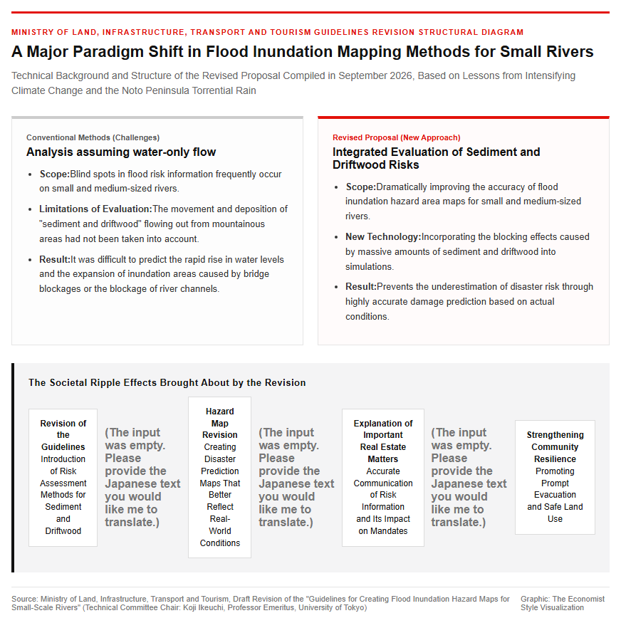
In September 2026, the Ministry of Land, Infrastructure, Transport and Tourism (MLIT) compiled a draft revision of the “Guidelines for Creating Flood Inundation Hazard Maps for Small-Scale Rivers,” which serve as a guideline for creating and revising flood inundation hazard maps for rivers. On September 30, 2026, a presentation ceremony for the draft revision was held, with Koji Ikeuchi, chair of the expert technical committee (Professor Emeritus at the University of Tokyo), handing it over to the Director-General of the Water and Disaster Management Bureau at the MLIT. This revision represents a major departure from conventional flood analysis methods that assumed only the flow of water. It aims to accurately evaluate and reflect the risk of rising water levels and expanding inundation areas caused by large amounts of sediment and driftwood flowing from mountainous areas and clogging rivers and bridges during the frequent heavy rains seen in recent years. This significant review enables more realistic and highly accurate damage predictions around small- and medium-sized rivers, which have often been blind spots for flood risk information, ultimately supporting prompt evacuation actions by local residents and promoting safe land use.
Challenges Highlighted by the Noto Peninsula Heavy Rain and the Northern Kyushu Heavy Rain
Behind the revision of the guidelines is the reality of severe flood damage that has become apparent in recent severe torrential rain disasters. In the July 2017 Northern Kyushu Heavy Rain and the September 2024 Noto Peninsula Heavy Rain, large amounts of sediment and driftwood generated in mountainous areas were transported downstream along with floods in small rivers mainly flowing through hilly and mountainous areas. At the same time as driftwood got caught in narrow bridge sections and dammed up water, sediment with a relatively small particle size accumulated within the river channel over a long section, resulting in a rapid reduction and clogging of the river cross-section, and leading to successive cases where flood flows spread all at once to surrounding residential and agricultural land. At the review meeting following the January 2024 Noto Peninsula Earthquake and the heavy rain in September of the same year, “the introduction of hazard maps anticipating the impact of sediment and driftwood” was strongly recommended. Since conventional flood simulations made it technically difficult to account for the rise in water levels caused by such driftwood trapping and sediment accumulation, the establishment of a practical evaluation approach had been urgently needed.
New Flood Risk Assessment Methods and the Development of Legal Frameworks
Introduction of Specific Indicators and Simplified Analysis Methods for Identifying Hazardous Rivers
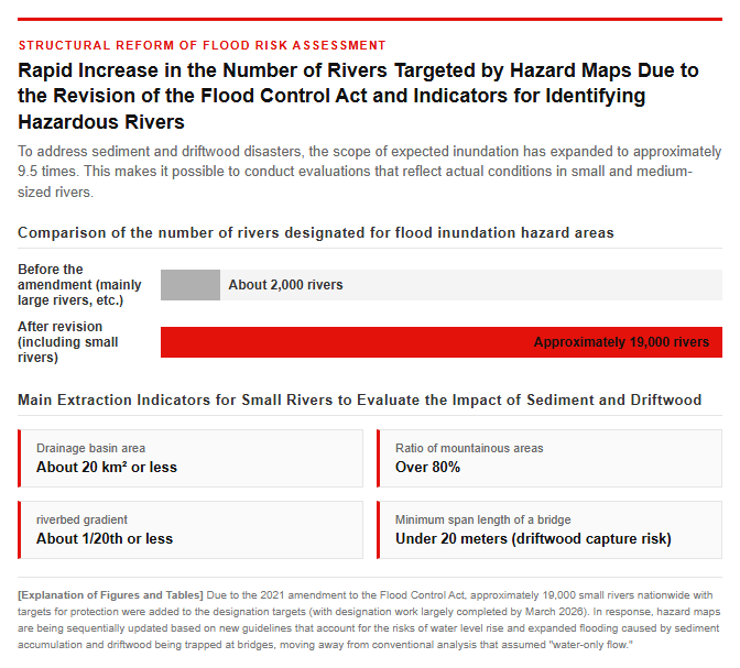
In the newly compiled revision draft, clear indicators have been established to extract high-risk rivers so that prefectures and municipalities nationwide can efficiently evaluate the vast number of small-scale rivers. It outlines the characteristics of rivers and sections susceptible to sediment and driftwood, such as a basin area of roughly 20 square kilometers or less, a mountainous area ratio of approximately 80 percent or more, and a riverbed slope of about 1/20 or less. Regarding the analysis method, instead of directly performing complex riverbed variation calculations—which entail massive computational costs and data challenges—it extracts points where driftwood is easily trapped, such as bridges with a minimum span length of less than 20 meters, as well as the starting points of sediment accumulation. From there, a relatively simple and practical approach is adopted in which the river channel shape after accumulation is set, and a one-dimensional non-uniform flow calculation for water flow only is performed. This aims to achieve both a reduction in the burden of on-site analysis work and the prompt creation and updating of flood inundation forecast maps.
Rapid Expansion of Areas Covered by Hazard Maps Based on the Revised Flood Control Act
This revision of the guidelines is deeply linked to the significant expansion of target areas for inundation mapping accompanying the amendment to the Flood Control Act. Until the 2021 amendment to the Flood Control Act, the designation of expected flood inundation areas was mainly limited to major rivers and designated flood forecast rivers and water level notification rivers (approximately 2,000 rivers). However, the legal amendment added all approximately 19,000 small rivers nationwide where protection targets such as houses and evacuation facilities exist to the designation scope. This nationwide designation work is generally completed by March 2026, and moving forward, based on the revised guidelines, each prefecture will proceed sequentially with updating to new inundation assumption area maps that take into account the effects of sediment and driftwood. In response to this, flood hazard maps prepared by municipalities will also be revised sequentially, improving the accuracy of local disaster prevention information, such as newly indicating hazard levels even in areas previously recognized as safe.
Ripple Effects on the Real Estate Market and Future Disaster Prevention Outlook
Important matters explanation and specific impacts on asset value and loan conditions
The revision of hazard maps also has a ripple effect on real estate transaction sites, residential asset values, and loan conditions. Since August 2020, based on the revised enforcement regulations of the Building Lots and Buildings Transaction Business Act, real estate agents have been obligated to present the latest flood hazard map to transaction parties and indicate the property’s location during important matter explanations in real estate sales and rentals. In areas where hazard maps are updated due to guideline revisions and flood risks due to sediment and driftwood are newly clarified, these risks are disclosed at the time of the transaction. Furthermore, the impact on housing purchase demand, liquidity, and maintenance costs is growing significantly, including mortgage collateral evaluations by financial institutions, fire insurance premium rates subdivided into five categories according to regional flood risks starting in October 2024, and the exclusion of mortgage tax deductions within disaster hazard areas for newly built homes occupied from 2028 onward.
Revision of Disaster Prevention Weather Information and Key Points for Future River Basin Flood Control
Moving forward, not only updating hazard maps, but also comprehensively promoting flood control by integrating soft and hard measures will be a critical focus. Regarding disaster prevention meteorological information from the Japan Meteorological Agency and other bodies, plans are underway to unify and change to an intuitive and easy-to-understand naming system starting in 2026, which will jointly display keywords such as “flooding,” “heavy rain,” “sediment disaster,” and “storm surge” alongside alert levels. Furthermore, in the sewerage sector, efforts are underway to advance planning methods that adjust future planned rainfall amounts by 1.1 to 1.3 times in anticipation of increased rainfall due to climate change, as well as to make sewerage facilities more water-resistant and encourage the installation of stormwater retention facilities. Real estate operators, homebuyers, and investors are required not to rely merely on past inundation history or memories of outdated maps, but to continuously check topographical risks and the latest information published by local governments, in order to select safe locations and implement appropriate disaster prevention measures.
Reference Page
- [Ministry of Land, Infrastructure, Transport and Tourism: “Compiled Methodology for Creating Flood Inundation Maps Accounting for the Impact of Sediment and Driftwood”] https://www.mlit.go.jp/mizukokudo/river/mizukokudo04_mn_000009.html
- [Ministry of Land, Infrastructure, Transport and Tourism “Hazard Map Portal Site”] https://disaportal.gsi.go.jp/
[#MinistryOfLandInfrastructureTransportAndTourism #HazardMap #FloodRisk #InundationArea #RealEstateImportantMattersExplanation #DisasterPreventionInformation]


コメント