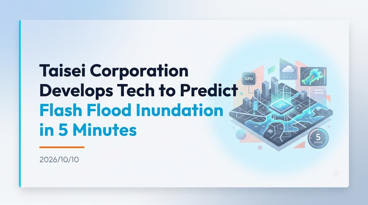
Taisei Corporation has developed a technology to predict urban inundation caused by localized heavy rainfall (sudden torrential rainstorms) within 5 minutes of rainfall data distribution. The aim is to enable prompt, real-time disaster prevention actions and evacuation orders against intensifying urban-type internal flooding driven by global warming and other factors.
- Taisei Corporation’s New Technology Predicts Flooding Conditions in 5 Minutes
- Damage and Background of Frequent Internal Flooding in Urban Areas
- Technical Structure of a Full-GPU Model Integrating 1D and 2D
- Analysis speed proven in verification experiments and accuracy in Asagaya
- Visualization using 3D city models linked with PLATEAU
- Future Prospects for Practical Application and Urban Flood Risk Management
Taisei Corporation’s New Technology Predicts Flooding Conditions in 5 Minutes
Taisei Corporation (Shinjuku-ku, Tokyo; President: Yoshiro Aikawa) has developed an analysis technology that predicts urban flooding conditions in real time within just five minutes of weather data distribution, addressing inland flooding in urban areas caused by the localized heavy rainfall (so-called “guerrilla rainstorms”) that has been occurring frequently in recent years.
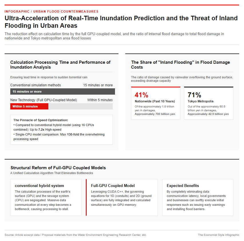
Because conventional simulation methods took 15 minutes or more to complete calculations, it was extremely difficult to secure the lead time needed to implement on-site hydraulic measures and issue evacuation orders to residents in response to sudden torrential rain. In this development, we have newly constructed a “full GPU-coupled model” that maximizes the parallel processing performance of the latest graphics processing units (GPUs) to its absolute limit.
The main features and points of this technology are as follows:
- Integrating 1D sewer pipe analysis and 2D surface flooding analysis entirely on the GPU
- Prediction completed within 5 minutes of data delivery from the Japan Meteorological Agency’s High-Resolution Precipitation Nowcast, etc.
- Eliminating compute communication bottlenecks to achieve up to 7x faster speeds compared to conventional methods
This creates an environment enabling municipal crisis management personnel and corporate facility managers to instantly assess flood risks and swiftly execute initial responses, such as issuing early warnings and installing flood barriers.
Damage and Background of Frequent Internal Flooding in Urban Areas
In recent years, due to the effects of global warming and the heat island phenomenon, extremely unpredictable short-duration heavy rainfall and torrential rains caused by linear rainbands have been occurring one after another across the country. Regarding flood damage in urban areas, there is a marked increase in the risk of not only external flooding, where water overflows from river levees, but also “internal flooding,” where rainwater exceeding the processing capacity of sewage systems and stormwater drainage facilities spills out onto the ground surface.
In major metropolitan areas with a high artificial coverage rate, such as asphalt and concrete, rainwater has difficulty infiltrating the ground, making roads and underground shopping areas prone to rapid flooding during torrential downpours.
According to recommendation documents from organizations such as the Water Environment Engineering Research Center, the actual state of damage from flood disasters shows the following clear numerical data:
- Of the approximately 1.8 trillion yen in flood damage nationwide over the past 10 years, about 41% (roughly 0.7 trillion yen) was caused by inland flooding.
- Of the approximately 60.5 billion yen in flood damage in Tokyo, as much as roughly 71% (approximately 42.9 billion yen) was caused by inland flooding.
Particularly in the capital region and major cities with advanced underground development, such as subway networks and underground shopping malls, enhancing inland flood countermeasures and providing real-time risk information have become top-priority social issues to protect human lives and urban functions.
Ultra-Fast Analysis Enabled by a Full-GPU Coupled Model
Technical Structure of a Full-GPU Model Integrating 1D and 2D
At the core of the new technology developed by Taisei Corporation is the “Full GPU Coupled Model” algorithm, which simultaneously and completely calculates the complex water flow inside the sewerage network (1-dimensional pipe flow shallow water equations) and the flood water flow on the ground surface (2-dimensional shallow water equations).
Conventional inundation analysis models have commonly used a hybrid approach in which two-dimensional calculations of the ground surface are performed on a GPU, while one-dimensional calculations of the sewer system are processed by a central processing unit (CPU). However, this method requires a large amount of water level and flow rate data to be communicated back and forth between the CPU and GPU at every time step, and this data transfer process has been a bottleneck that significantly slows down the overall calculation speed.
To address this challenge, Taisei Corporation has independently developed a program that uses CUDA C++ to uniformly compute both 1D and 2D fundamental equations within the GPU memory space.
- Eliminating communication latency by completing 1D and 2D data communication within the GPU
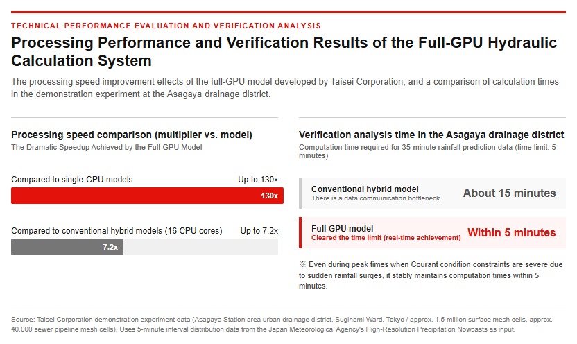
- Up to 7.2x faster compared to the conventional hybrid model (using 16 CPU cores)
- Achieving an overwhelming processing speed of up to 130 times compared to a single CPU model.
The establishment of this groundbreaking computational structure has made it possible to execute detailed hydraulic calculations for entire vast urban areas in real time.
Analysis speed proven in verification experiments and accuracy in Asagaya
To verify the practicality and high prediction accuracy of this technology, Taisei Corporation conducted a verification analysis targeting the urban drainage district around Asagaya Station in Suginami Ward, Tokyo, where severe internal flooding had actually occurred in the past.
The targeted Asagaya drainage district is a large-scale and complex urban model consisting of a ground surface mesh of approximately 1.5 million cells and a sewer pipe mesh of approximately 40,000 cells. In the validation, based on data from the localized torrential rain on August 27, 2018, 35-minute rainfall prediction data obtained from the Japan Meteorological Agency’s High-Resolution Precipitation Nowcast (250m mesh, distributed every 5 minutes) was inputted, and inundation prediction simulations were continuously repeated every 5 minutes.
The main results confirmed in the demonstration experiment are as follows.
- While the conventional hybrid model took about 15 minutes for analysis, the full-GPU model completed all calculations within the 5-minute time limit.
- Even during peak times when rainfall surges rapidly and constraints due to the Courant condition become stringent, it consistently maintains computation times of under 5 minutes.
- The calculated distribution of inundation depth and extent showed an extremely high level of agreement with the actual inundation record maps by the Tokyo Metropolitan Government.
This demonstration proved that this system achieves both sufficient analysis accuracy and a practical response speed during actual heavy rain events.
Integration with the 3D City Model PLATEAU and the Deployment of Disaster Prevention DX
Visualization using 3D city models linked with PLATEAU
Taisei Corporation has developed a visualization system utilizing open data from “PLATEAU,” a 3D city model development project promoted by the Ministry of Land, Infrastructure, Transport and Tourism (MLIT), to enable the intuitive on-site utilization of analysis results obtained from an ultra-high-speed computational engine.
This system automatically acquires elevation data and detailed building layout data for the target area from PLATEAU, and creates an advanced regional dataset by integrating sewerage facility and microtopography data. Then, it overlays and displays the constantly changing inundation depths and water flow directions derived from the analysis in real time on the 3D city model.
The primary benefits and use cases of implementing the system are as follows.
- Three-dimensional display of flood risks for specific buildings and underground shopping mall entrances, which are difficult to grasp with flat hazard maps.
- Allows you to visually confirm the flooding progression process while freely changing your eye-level position and viewpoint.
- Simulating the effectiveness of installing flood barriers and seawalls in advance to support the formulation of Business Continuity Plans (BCP)
Through three-dimensional visual representations, stakeholders such as government disaster prevention officials, urban developers, and building managers can accurately share a visualization of flood damage, contributing to rapid consensus-building and the formulation of highly effective disaster prevention measures.
Future Prospects for Practical Application and Urban Flood Risk Management
According to a survey by Yano Research Institute, the domestic disaster prevention information systems market in 2024 is estimated at 18.4 billion yen, and as climate change risks become increasingly apparent, demand is rapidly expanding for “disaster prevention DX,” which visualizes risks during normal times and enables immediate response in emergencies.
The technology developed by Taisei Corporation is applied not only to internal flooding caused by sudden localized heavy downpours, but also to the analysis of overtopping phenomena caused by tsunamis and storm surges. By constructing a “2D-3D coupled model” that integrates the open-source 3D fluid analysis code “OpenFOAM” with a 2D model, the company has also succeeded in cutting calculation time by approximately half while maintaining accuracy comparable to full-domain 3D analysis for complex hydraulic phenomena such as wave propagation and overtopping.
Future prospects and societal expectations are as follows.
- Achieving high-accuracy forecasting integrated with real-time sensing technology for water levels inside pipes and AI rainfall prediction
- Evolution into Automated Remote Control Systems for Drainage Pump Stations and Sluice Gates Based on Inundation Prediction
- Proactive Solution Proposals to Local Governments and Private Enterprises Aimed at Promoting Disaster Prevention DX from 2025 Onwards
Amid growing concerns over the intensification of flood damage due to climate change, high expectations are being placed on the creation of a next-generation urban flood risk management system that highly integrates hardware development and digital technology.
Reference page
- [Taisei Corporation News Release] Development of Analysis and Display System for Internal Flooding and Inundation Occurrences [suspicious link removed]
- [Taisei Corporation Technology Center Report Vol. 58 (2025)] Numerical Analysis Using a Coupled Model Targeting Wide-Area Urban Inundation Phenomena https://www.taisei.co.jp/tact/tr/2025/paper/A058_037.pdf
- [Ministry of Land, Infrastructure, Transport and Tourism] 3D City Model Development, Utilization, and Open Data Project “PLATEAU” https://www.mlit.go.jp/plateau/
- [Yano Research Institute Press Release] Conducted a Survey on the Disaster Prevention DX Market (2025) [suspicious link removed]
[#TaiseiCorporation #GuerrillaRainstorms #InundationPrediction #InternalFlooding #DisasterPreventionDX #PLATEAU #FloodCountermeasures]

コメント