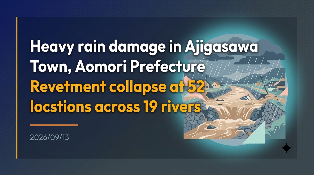
Torrential rain brought by linear precipitation zones triggered riverbank collapses and flooding across 52 locations along 19 rivers in Ajigasawa Town, Aomori Prefecture. Driven by steep local topography and increasingly frequent localized downpours, urgent river interventions and comprehensive basin-wide flood management have become critical for the region.
- Record Rainfall and Key Takeaways from Bank Failures Across 19 Rivers
- Inundation Damage to Residential Areas and Infrastructure, and Economic Impacts
- Analysis of Inundation Mechanisms: Topographic Features and Climate Change
- Landslides and Altered River Courses Destroying Local Residential Roads
- The Emergency Project for Severe Disaster Mitigation on the Nakamura River and Levee Construction
- Designation as a “Specified Urban River” and Statutory Flood Prevention Frameworks
- West Tsugaru Regional Resilience Plan and Future Reconstruction Outlook
Record Rainfall and Key Takeaways from Bank Failures Across 19 Rivers
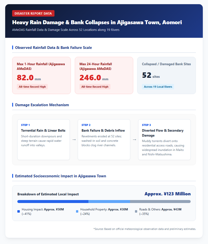
In Ajigasawa Town, Nishitsugaru District, Aomori Prefecture, lingering atmospheric fronts and linear precipitation zones have caused an unprecedented series of localized heavy downpours. During severe rainfall in early September 2026, the Japan Meteorological Agency’s Ajigasawa AMEDAS observation station recorded 82.0 mm of hourly rainfall and a 24-hour total of 246.0 mm, setting new all-time records for the location. This torrential rain caused water levels in local rivers to surge rapidly, resulting in bank collapses or severe structural damage across 52 locations along 19 rivers, including the Nakamura River.
The destruction of revetments went beyond mere structural damage; eroded soil and collapsed concrete blocks washed into river channels, clogging waterways and triggering secondary disasters. Massive volumes of muddy water spilled into nearby sloped areas and local residential roads, leaving deep scars particularly in the Maito and Nishi-Matsushima districts of Ajigasawa Town. Please refer to the diagram below.
Preliminary administrative surveys indicate that civil engineering damages and riverbank repair costs will be substantial. In response, emergency restoration work, including the installation of large sandbags and debris removal, has been underway around the clock since immediately after the disaster.
Inundation Damage to Residential Areas and Infrastructure, and Economic Impacts
The riverbank collapses and subsequent river flooding dealt a direct blow to the daily lives of residents and the local economy in Ajigasawa Town. In the town center and residential neighborhoods, inland pluvial flooding and river overflow occurred simultaneously, causing widespread road submergence as well as above- and below-floor inundation in numerous homes and commercial shops. Following a severe flood in August 2022 that inundated 367 households (305 above-floor, 62 below-floor), the September 2026 torrential rain once again inflicted extensive damage on homes and household property.
According to socioeconomic impact estimates by a private weather intelligence firm, the total estimated impact across 12 municipalities in Aomori Prefecture from the September 2026 heavy rain reached approximately 530 million yen. Within Ajigasawa Town alone, the economic impact was estimated at approximately 123 million yen. A breakdown shows that impacts on housing accounted for approximately 50 million yen, while household property damage reached approximately 30 million yen, meaning housing-related losses comprised over 60% of the town’s total impact.
Public infrastructure and commercial facilities suffered severe disruptions as well. Major transport arteries, including the JR Gono Line and the National Route 101 Bypass, were temporarily closed due to roadway submergence and shoulder damage. Local businesses were also hard hit; for example, a local bookstore saw its inventory of books and retail fixtures submerged, forcing their disposal and incurring significant financial losses that threaten business continuity.
Structural Causes of the Nakamura River Flooding and History of Recurrent Disasters
Analysis of Inundation Mechanisms: Topographic Features and Climate Change
The recurrent flood disasters in Ajigasawa Town stem from a complex interaction between unique local geography and recent climate change. The main river traversing the town, the Nakamura River, has a total channel length of 44.9 kilometers and a basin area of 149.0 square kilometers. In its mountainous upper reaches, the channel is relatively narrow at 20 to 30 meters wide, with a steep riverbed gradient of approximately 1:50. Consequently, heavy rainfall quickly concentrates rainwater from steep mountain slopes directly into the river valley.
In contrast, as the river flows into the urbanized lower reaches, the channel widens to 40 to 50 meters, but the riverbed gradient flattens dramatically to approximately 1:900, creating a tidal reach influenced by ocean tides. As a result, massive surges of muddy water from upstream tend to stagnate in the lower reaches, creating a structural bottleneck where floodwaters easily exceed channel discharge capacity and inundate low-lying urban areas. Please refer to the diagram below.
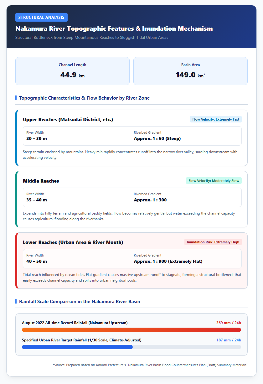
Furthermore, driven by global warming, the frequency of linear precipitation zones delivering intense, short-duration downpours over localized areas has increased. In the Nakamura River basin, 24-hour cumulative rainfall reached an all-time high of 369 mm at the Nakamura Upstream observation station in August 2022, demonstrating how recent extreme weather events repeatedly exceed the rainfall thresholds originally assumed in conventional river management plans.
Landslides and Altered River Courses Destroying Local Residential Roads
Among the 52 bank collapse sites across 19 rivers, landslides occurring in mountainous areas and along small streams adjacent to residential neighborhoods served as the primary driver behind blocked access roads and expanding flood zones. During the September 2026 heavy rain, hillside failures occurred on slopes behind residential neighborhoods in areas such as West Matsushima, Maito-cho, Ajigasawa Town.
Collapsed earth, rock, and uprooted trees completely blocked existing small streams and drainage channels. Deprived of their natural course, raging torrents diverted onto residential roads, transforming quiet neighborhood streets into rushing rivers and severely eroding asphalt pavements. Road centers cracked and bulged unevenly, while side ditches and retaining walls collapsed, leaving widespread destruction in the wake of the powerful currents.
The diverted torrents directly struck private properties, warehouses, and storage sheds along the roads, washing away large quantities of agricultural machinery and equipment. Muddy water rushed into homes above floor level, forcing residents into emergency evacuations and grueling mud-clearing operations. This highlighted a dangerous disaster mechanism where hillside landslides clog tributaries and alter flow paths, causing secondary destruction to riverbanks and road networks beyond main river overflows.
A 5 Billion Yen River Improvement Project and Shift Toward “River Basin Disaster Resilience and Management”
The Emergency Project for Severe Disaster Mitigation on the Nakamura River and Levee Construction
In response to repeated large-scale flood disasters, the river manager—Aomori Prefectural Government—along with Ajigasawa Town, secured approval for the “Emergency Project for Severe Disaster Mitigation” under the national subsidy framework, embarking on fundamental river improvement works for the Nakamura River. This major flood control project entails a total investment of 5 billion yen (including 2.5 billion yen in national funding) over a five-year period from FY2022 to FY2026.
Specific engineering measures include 400 meters of levee construction, 1,400 meters of channel excavation to enhance flow capacity through the lower urban reaches, and 1,300 meters of reinforced revetment work (800 meters on the left bank and 500 meters on the right bank). In the revetment sections, temporary repairs made with large sandbags are being upgraded into robust concrete riverbanks designed to withstand heavy water pressure and floating debris impact. Please refer to the diagram below.
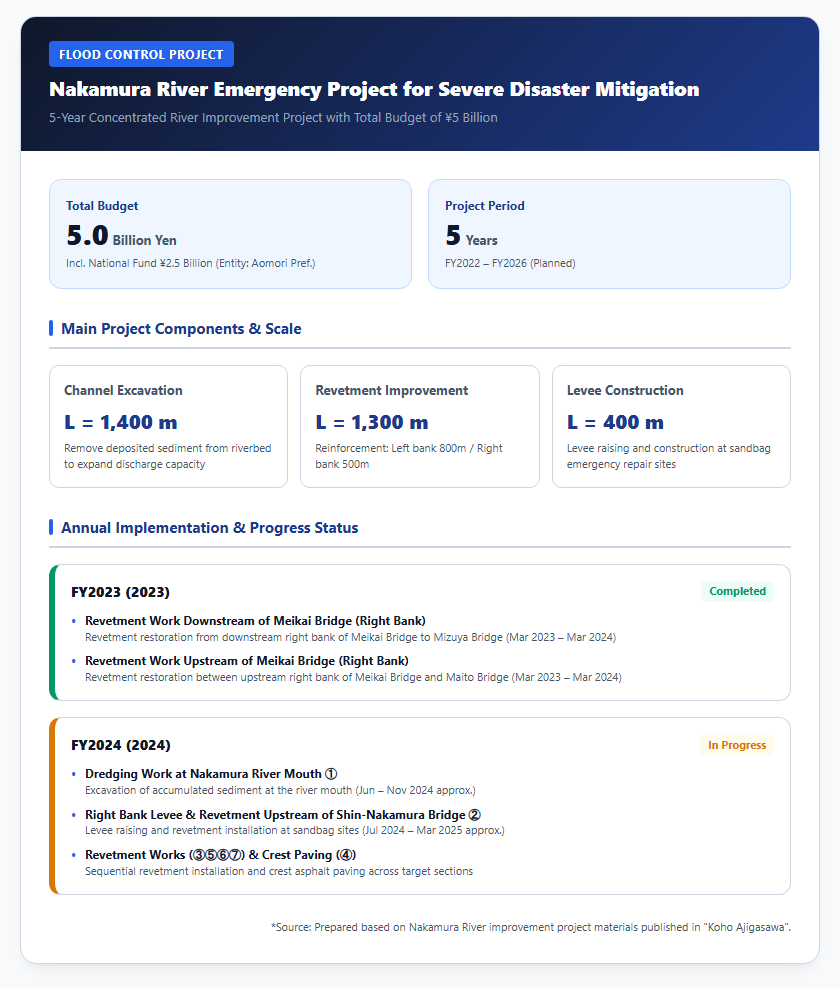
Between FY2023 and FY2024, revetment work on the right bank both upstream and downstream of the Meikai Bridge was completed, along with sediment dredging at the mouth of the Nakamura River and levee construction upstream of the Shin-Nakamura Bridge. These physical interventions are steadily reducing overflow risks associated with design-level rainfall events.
Designation as a “Specified Urban River” and Statutory Flood Prevention Frameworks
To complement structural engineering with statutory frameworks for comprehensive flood management, Aomori Prefecture designated three rivers in the Nakamura River system—the Nakamura River, Tokumei River, and Horikiri River—as “Specified Urban Rivers” on July 31, 2024. This marked the first such designation for prefecturally managed rivers in Aomori Prefecture.
Under the Act on Countermeasures against Inundation Damage by Specified Urban Rivers, this legal designation established a cooperative structure uniting river managers, sewerage operators, local governments, businesses, and residents to advance integrated structural and non-structural “River Basin Disaster Resilience and Management.” Following the designation, any land development activity exceeding 1,000 square meters that impairs soil rainwater infiltration within the basin requires prior approval from the Governor of Aomori Prefecture, along with mandatory installation of rainwater infiltration facilities or detention basins to suppress peak runoff.
Furthermore, the “Nakamura River Basin Flood Countermeasures Council,” comprising administrative bodies and local stakeholders, is formulating the “Nakamura River Basin Flood Countermeasures Plan” targeted at design rainfall scales (such as 187 mm of 24-hour rainfall). The plan incorporates measures such as rainwater storage and infiltration facilities, the implementation of “Paddy Field Dams” utilizing agricultural land, and flood-risk-informed land-use regulations.
West Tsugaru Regional Resilience Plan and Future Reconstruction Outlook
Ajigasawa Town, jointly with neighboring Tsugaru City and Fukaura Town, established the “West Tsugaru Regional Resilience Plan” to strengthen wide-area pre-disaster prevention and mitigation capabilities. Originally formulated in March 2021 and revised in March 2026, the plan spans a five-year period from 2026 to 2030, serving as a strategic roadmap to protect residents’ lives and property from major natural disasters while maintaining safe socioeconomic activities.
The plan systematically addresses both structural and non-structural measures, including seismic and flood-proofing of transportation infrastructure such as roads and bridges, securing evacuation routes, and digitizing disaster management radio networks. In Ajigasawa Town specifically, alongside river improvements on major waterways like the Nakamura and Akaishi rivers, key priority projects include the public release of urban pluvial flood hazard maps (published in April 2025) and the construction and expansion of three drainage pumping stations near Ajigasawa Station, Kamitomita, and Gamo to mitigate internal inundation.
Going forward, addressing increasingly severe climate change will require continuous verification of existing disaster prevention facilities and ongoing progress reviews of flood control projects. The ultimate focus for Ajigasawa Town’s reconstruction and disaster risk reduction lies in combining the swift restoration and structural reinforcement of the 52 bank collapse sites across 19 rivers with land-use guidance toward lower-risk areas and enhanced community-based disaster resilience, thereby building a tough and flexible disaster-resilient community.
Reference Pages
- 【Publication of the August 2022 Torrential Rain Disaster Record for Ajigasawa Town】https://www.town.ajigasawa.lg.jp/bosai_jyoho/kikakusinkou.html
- 【West Tsugaru Regional Resilience Plan – Ajigasawa Town】https://www.town.ajigasawa.lg.jp/bosai_jyoho/bousai022021092117.html
【#AomoriPrefecture #AjigasawaTown #TorrentialRainDamage #BankCollapse #NakamuraRiver #SpecifiedUrbanRiver #RiverBasinDisasterResilience #NationalResilience】


コメント