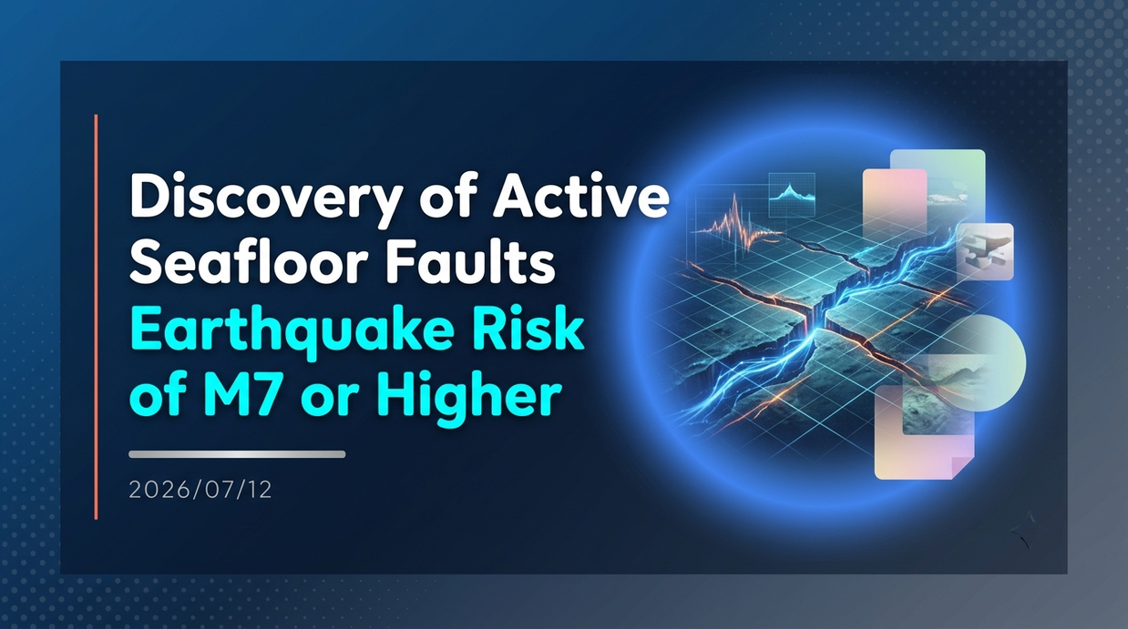
A research team from the National Institute of Advanced Industrial Science and Technology announced that they have confirmed two new active submarine faults at Hiuhinada, located in the central part of the Seto Inland Sea. With the clarification of a magnitude 7 earthquake risk in a blank area that had not been sufficiently surveyed until now, discussions have begun to review regional disaster prevention plans and damage estimates.
- The size and location of the two discovered faults
- Research Methods and Their Accuracy
- The risk of unexplored gaps
- AIST’s New Project and Rapid Information Dissemination
- Governor Nakamura’s Press Conference and Call for Calm Response
- Anticipated Linked Earthquakes and Threats to Cities
- Elucidation of Earthquake History through Excavation Surveys
- Promotion of Geological Information DX and Wide-Area Collaboration
The size and location of the two discovered faults
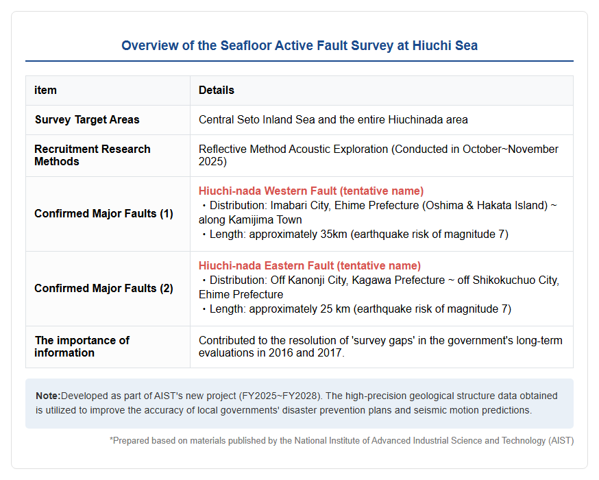
A research team from the National Institute of Advanced Industrial Science and Technology (AIST) conducted a detailed seafloor active fault survey covering the entire Hichinada Sea, located in the central Seto Inland Sea, clarifying the distribution of two major active faults. Specifically, the confirmed faults include the approximately 35-kilometer-long ‘Hiuchi-nada Western Fault’ (tentative name), which runs along Oshima and Hakata Islands in Imabari City, Ehime Prefecture to Kamijima Town, and the ‘Hiuchi-nada Eastern Fault (tentative name),’ about 25 kilometers long, stretching from offshore Kanonji City in Kagawa Prefecture to off Shikokuchuo City, Ehime Prefecture. It has been pointed out that all of these faults could potentially trigger magnitude 7 earthquakes in the future. Until now, the area around Hiuchinada had no active faults shown in the 2016 “Long-term Evaluation of Active Faults in the Chugoku Region” and the 2017 “Long-Term Evaluation of Active Faults in the Shikoku Region,” leaving it a blank area for national evaluation. This discovery clarifies earthquake disaster risks that had previously been overlooked through scientific data, and is expected to have a significant impact on widespread disaster prevention measures along the Seto Inland Sea coast. The following diagram shows the geological information development of Hiuchi-nada, which was the subject of the survey.
Research Methods and Their Accuracy
The identification of this active fault employed the latest method called reflective sonar exploration. This survey was conducted throughout Hiuchi-nada from October to November 2025, artificially generating sound waves near the surface and analyzing waves reflected back at the boundary of strata beneath the seabed, thereby successfully visualizing the precise geological structure beneath the seabed. According to data released by AIST, these faults have repeatedly experienced earthquakes in the past, and each time, the northwest side of the fault has been relatively elevated. In sea areas like Hiuchi-nada, it was difficult to accurately grasp the location and activity history of active faults compared to land areas, resulting in delays in surveys. However, this project enabled the acquisition of highly accurate fault information. AIST states that to predict when, where, and on what scale the next earthquake will occur, it is extremely important not only to understand the fault’s location and length but also to understand the timing and frequency of past activity. The results of this sonar survey have provided foundational data for estimating the magnitude of the earthquake.
[Background of the Survey] Why Hiuchinada has attracted attention now?
The risk of unexplored gaps
The reason Hiuchi-nada was the focus of this intensive survey is the growing urgency of earthquake disaster prevention along Japan’s coastal areas. In particular, the Noto Peninsula earthquake that occurred in January 2024 once again highlighted how massive earthquakes originating from active seabed faults can cause severe damage to coastal areas. The Japanese archipelago is located at plate boundaries, and there is always a risk of trench-type earthquakes and inland active fault earthquakes. However, compared to the history of modern seismology since the Meiji era, the frequency of major earthquakes has been low, and conventional data alone was insufficient for future predictions. Although the government’s Earthquake Research Promotion Headquarters (Earthquake Headquarters) has led nationwide active fault surveys, there are still gaps in the Seto Inland Sea for investigation, and many faults have not yet been evaluated for their earthquake probability. At Hiuchi-nada, although there were reports in the early 2000s suggesting the existence of faults, no comprehensive survey of the entire sea area had been conducted. Such a lack of information has become a factor reducing the accuracy of regional earthquake damage estimation and disaster planning, making the elimination of these gaps an urgent issue.
AIST’s New Project and Rapid Information Dissemination
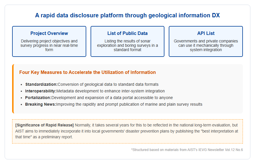
This survey was conducted as part of a new project by AIST starting in fiscal 2025: “High-Precision Geological Information Development Project for Earthquake Disaster Prevention and Mitigation in Coastal Areas (FY2025–2028).” This project is positioned as part of the Ministry of Economy, Trade and Industry’s “3rd Intellectual Infrastructure Development Plan,” aiming to acquire new data on marine active faults, including those along the Seto Inland Sea coast. AIST has announced a policy to promptly disseminate information when new information is obtained from surveys. Normally, it takes several years for the results of active fault investigations to be published as long-term national assessments, but in past major earthquakes, there have been cases where earthquakes occurred within the time lag between survey completion and assessment reflection. Therefore, even if AIST’s opinions may change in the future at expert meetings, it promptly publishes data that best interprets it at that time and has it to be useful for local disaster prevention planning. This approach led to the rapid announcement of the discovery of an active fault at Hiuchinada. The diagram below illustrates the information dissemination platform promoted by AIST.
[Political and Social Reactions] Administrative Response and Impact on Disaster Prevention
Governor Nakamura’s Press Conference and Call for Calm Response
Following the discovery of a new submarine active fault, Ehime Prefecture Governor Tokihiro Nakamura mentioned this at a regular press conference on June 15, 2026. Governor Nakamura emphasized that, although the existence of the fault has been confirmed at this stage, details such as the scale of the earthquake and its history of past activity have not yet been clarified. Therefore, they explained that there is no immediate plan to review the prefecture’s disaster prevention plan at this time, and they have shown a cautious attitude of wanting to assess the detailed results of future investigations. Additionally, the governor urged residents not to become overly anxious and to calmly accept new findings. From an administrative perspective, the stance is to wait for further scientific evidence to accumulate before reflecting it in concrete measures. On the other hand, for residents and businesses along the Seto Inland Sea coast, the fact that previously unexpected epicenter sites exist nearby has become an opportunity to reaffirm their daily preparedness. In particular, many factories and port facilities are concentrated around Hiuchi-nada, raising concerns about the impact of the earthquake on economic activity.
Anticipated Linked Earthquakes and Threats to Cities
This discovery has also intensified discussions about the possibility that faults around the Seto Inland Sea could move in tandem as a ‘single system.’ Experts around Hiroshima point out that the Iwakuni–Itsukaichi Fault Zone, Akinada Fault Zone, Hiroshima Bay–Iwakuni Offshore Fault Zone, and the newly proposed submarine fault all form a single interconnected network. If a chain destruction of submarine faults like those seen in the Noto Peninsula earthquake occurs in the Seto Inland Sea, the worst-case scenario would be three stages of damage. First, the destruction of massive faults on the seabed causes tsunamis and liquefaction, paralyzing port functions. Next, the Akinada Fault Zone and other areas are stimulated, causing strong shaking that strikes the city, ultimately destroying the fault directly beneath the city. Traditional disaster prevention assumptions often assume that individual faults move independently, but this discovery reconsiders that assumption and highlights the need for structural countermeasures that consider the possibility of simultaneous activities.
[Future Developments] Detailed Surveys and Advancement of Regional Disaster Prevention
Elucidation of Earthquake History through Excavation Surveys
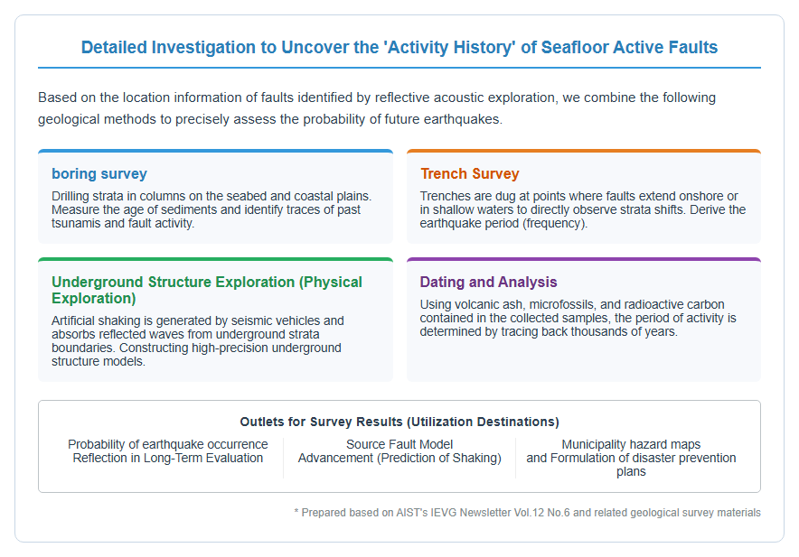
Going forward, more detailed surveys are planned to clarify the past activity of identified submarine faults. Specifically, we will conduct offshore boring and offshore trench surveys to directly estimate the earthquake history (activity history) of when and how often earthquakes have occurred in the past. This will enable the evaluation of future earthquake probabilities and promote reflection in the country’s long-term evaluations. AIST is also advancing the acquisition of underground geological information in coastal plains such as the Okayama, Matsuyama, and Hiroshima plains, and by combining source fault information with understanding ground structure, it is possible to achieve more accurate prediction of shaking (seismic motion prediction). Geological surveys that decipher traces of past major earthquakes from strata are essential steps to ensure preparedness for an uncertain future. The following diagram shows a trench survey conducted by extending the survey of marine active faults onshore.
Promotion of Geological Information DX and Wide-Area Collaboration
The advanced geological information obtained is expected not only to be published as research results but also to be widely returned to society by utilizing digital technology. AIST’s promotion of geological information DX (Digital Transformation) aims to convert undigitized geological maps into standardized data formats and create an environment that enables collaboration across diverse fields. This enables government agencies and private companies to quickly utilize data and use it to formulate effective disaster prevention plans and business continuity plans (BCPs). Furthermore, since the Seto Inland Sea is a vast body of water spanning multiple prefectures, wide-area coordination to transport emergency supplies and maintain port functions during earthquakes is crucial. By filling the “blank areas” in the Seto Inland Sea and revealing the full picture of the fault network, the foundation for “national resilience” will be established for municipalities in Shikoku and the Chugoku region to cooperate in facing large-scale disasters.
[#地震防災 #産総研 #燧灘 #海底活断層 #愛媛県 #瀬戸内海 #南海トラフ地震 #防災計画]


コメント