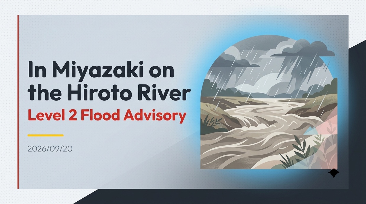
Due to heavy rainfall, water levels rose along the Hirowata River, a class-two river in Miyazaki Prefecture, prompting the issuance of a Level 2 Flood Advisory. This situation is driven by a wet climate with annual precipitation exceeding 2,700 millimeters and unique basin characteristics that have historically caused frequent flooding.
- Heavy Rain and Rapid Water Level Rise Triggered by the Approaching Typhoon
- Level 2 Flood Advisory Issuance and Emergency Information Dissemination
- High-Rainfall Climate Exceeding 2,700 mm Annually and Inundation Risks in the Nichinan Plain
- Lessons Learned from Typhoon No. 19 in 1997 and Typhoon No. 14 in 2005
- Progress on River Improvement Projects under the Hirowata River System Improvement Plan
- Integrated Structural and Non-Structural Strategies by the Nichinan-Kushima Risk Reduction Council
Heavy Rain and Rapid Water Level Rise Triggered by the Approaching Typhoon
Due to the approach of a typhoon and a stagnant autumn rain front, heavy and intermittent rainfall was recorded across various parts of Miyazaki Prefecture. In particular, within the Hirowata River system flowing near Nichinan City, large volumes of rainwater from the mountainous upstream area poured into the river system in a short period, causing water levels to surge rapidly. Weather agencies and local governments urged residents to exercise extreme caution against potential flooding. As the Hirowata River and its largest tributary, the Sakatani River, reached flood warning thresholds, authorities issued a Level 2 Flood Advisory. Monitoring cameras and river gauging stations confirmed that the sudden surge significantly elevated the risk of overflow into unbanked river stretches and floodplains, requiring strict vigilance from surrounding communities. Analysis from meteorological agencies indicated that 24-hour rainfall exceeded 200 millimeters in coastal Pacific areas of Kyushu, with localized downpours persisting over extended periods. The following chart illustrates the weather analysis and flow conditions.
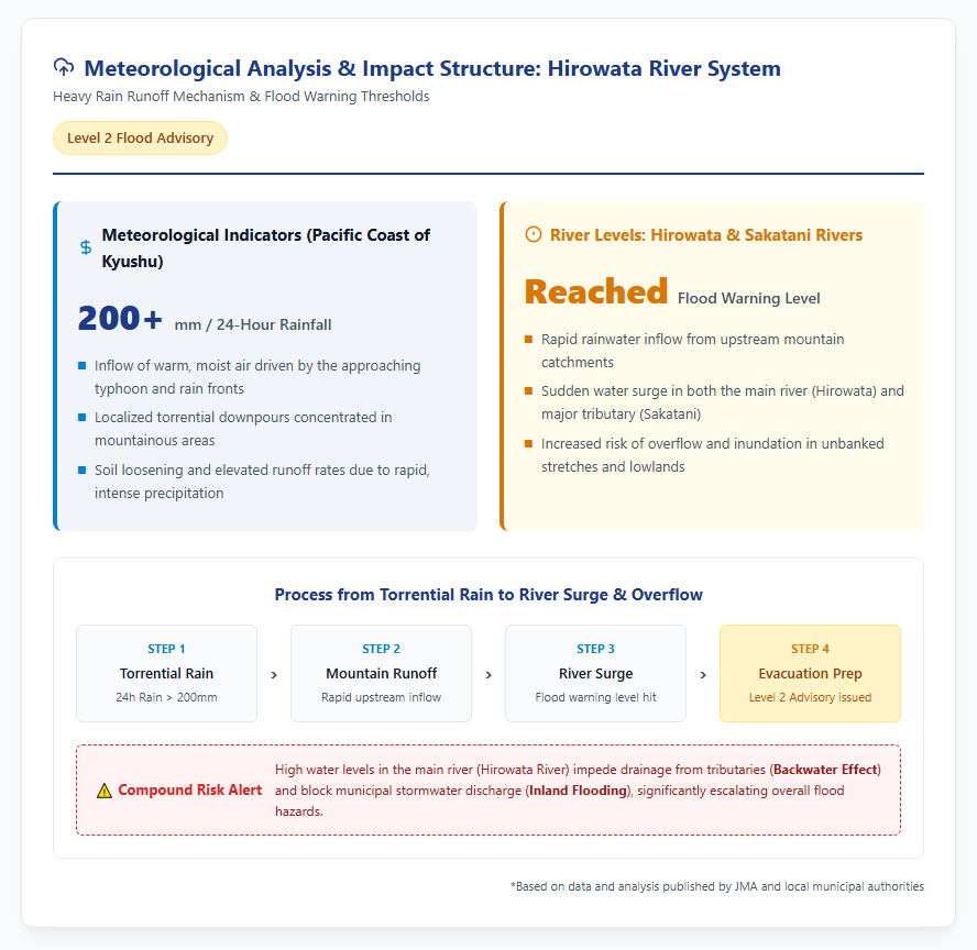
Under such intense torrential rain, the rising main river also threatened to impede drainage from tributaries, raising serious concerns over backwater effects and inland flooding that demanded swift, basin-wide coordination.
Level 2 Flood Advisory Issuance and Emergency Information Dissemination
A Level 2 Flood Advisory serves as a crucial disaster management milestone, signaling that residents should begin preparing for potential evacuation based on river level observations. In response, Miyazaki Prefectural authorities and Nichinan City utilized municipal disaster broadcast systems, area emergency alerts, and smartphone disaster notification apps to urge coastal and riverbank residents to stay vigilant and monitor updated forecasts. To streamline inter-agency communication, a direct hotline was activated between the Nichinan Civil Engineering Office and Nichinan City Hall, allowing real-time data regarding flood-alert and evacuation-judgment thresholds to reach crisis management personnel instantly. During past flood events, challenges such as muffled audio from outdoor speakers during heavy storms and delays in reaching residents unassigned to email alert systems were noted; thus, multi-channel communication strategies were actively deployed. Residents were urged to review hazard maps to confirm estimated inundation depths near their homes and prepare for voluntary evacuation. Although the advisory was lifted once water levels fell below the threshold, officials warned that loosened soil following heavy rain maintains a lingering risk of landslides.
Geographical Characteristics and Historical Major Flood Disasters in the Hirowata River Basin
High-Rainfall Climate Exceeding 2,700 mm Annually and Inundation Risks in the Nichinan Plain
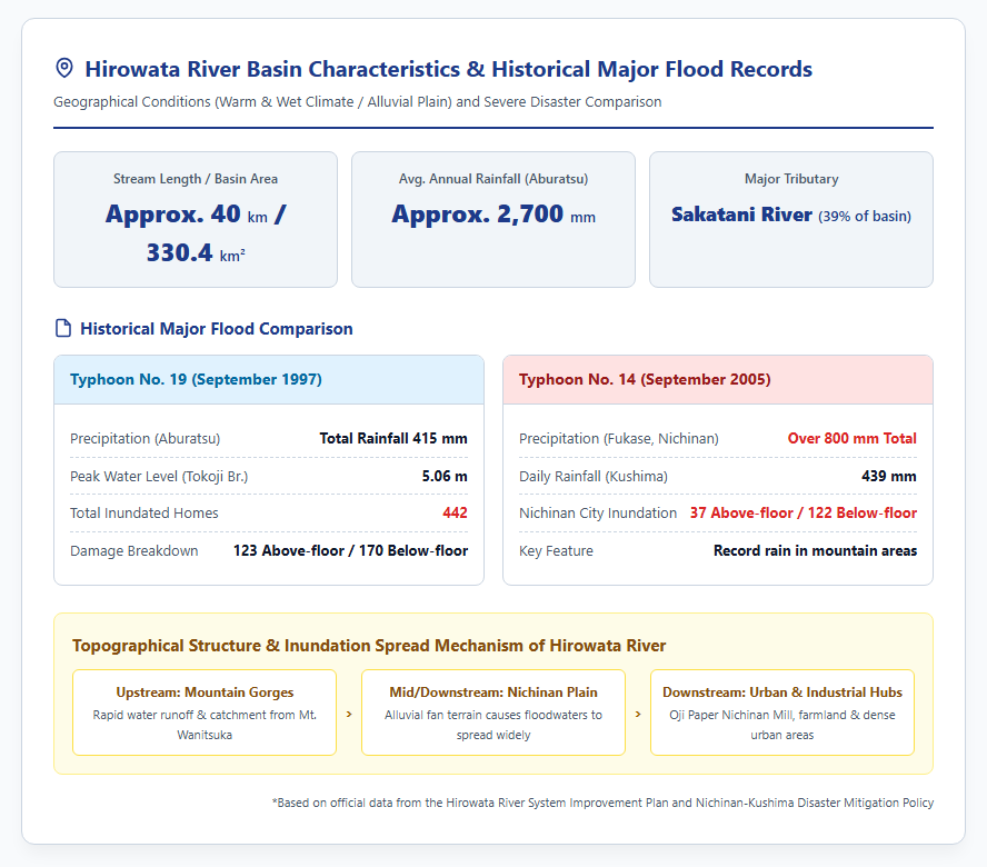
Originating at Mount Wanitsuka in southern Miyazaki Prefecture, the Hirowata River flows roughly 40 kilometers through mountainous terrain while collecting tributaries like the Kuronida and Inohae rivers, before merging with its main tributary, the Sakatani River, near its mouth to empty into the Hyuga-nada Sea. The river basin covers an area of 330.4 square kilometers. The basin experiences a warm and wet climate, with average annual rainfall reaching approximately 2,700 millimeters at the Aburatsu weather station. Torrential downpours occur frequently during the June–July rainy season and the August–September typhoon season, with typhoons accounting for the vast majority of major flood events. Topographically, the river exits narrow mountain gorges upstream to flow directly into the Nichinan Plain—a delta-like fan formation—meaning that any lower-basin flooding quickly spreads across vast areas. Furthermore, the downstream region houses the urban center of Nichinan City, rich agricultural lands, and key industrial hubs such as the Oji Paper Nichinan Mill (now Oji Holdings), making the social and economic ramifications of flooding exceptionally severe. The following graphic illustrates historical river surges and landslide hazards in the region.
Lessons Learned from Typhoon No. 19 in 1997 and Typhoon No. 14 in 2005
The Hirowata River basin has a long history of severe flood disasters. In September 1997, Typhoon No. 19 stalled over southern Kyushu, causing both the Hirowata and Sakatani rivers to swell. Water overflowed from unbanked sections and bottleneck stretches with insufficient flow capacity, inundating 442 homes and inflicting widespread damage on the local community. Later, in September 2005, Typhoon No. 14 brought record-breaking rainfall exceeding 800 millimeters to the Fukase area in Nichinan City, leading to 37 above-floor and 122 below-floor home inundations across the municipality. These repeated disasters underscored that relying solely on physical engineering—such as dikes and revetments—was insufficient, sparking a stronger emphasis on non-structural measures like evacuation system enhancements and hazard map distribution. However, as years pass without major events, decaying public awareness and generational shifts risk eroding disaster memory, making ongoing disaster education and community preparedness vital priorities.
Current Status of Flood Control Measures and Challenges for Regional Risk Reduction
Progress on River Improvement Projects under the Hirowata River System Improvement Plan
As the primary river manager, Miyazaki Prefecture formulated the Hirowata River System River Improvement Plan to prevent and mitigate flood damage through systematic engineering projects. The plan sets a flood control target capable of safely discharging a 50-year rainfall event (equivalent to the September 1997 Typhoon No. 19 flood) at the Hirotabashi Bridge section on the main river. Similar channel excavation, embankment construction, and revetment works have been carried out along tributaries, including the Sakatani and Todaka rivers, to enhance discharge capacities. Historically, open retarding dikes (kasumitei) were used along the Hirowata River to allow controlled flooding; however, shifting land-use patterns and urban expansion necessitated a transition to continuous levee systems and riverbed dredging. Nevertheless, several stretches remain under construction or possess inadequate flow capacity, demanding further safety upgrades in the face of climate-driven rain intensity increases. Future implementation must balance flood protection with environmental preservation and public riverfront access.
Integrated Structural and Non-Structural Strategies by the Nichinan-Kushima Risk Reduction Council
Because physical river infrastructure requires substantial time and capital, regional disaster management operates under the premise that catastrophic events exceeding design capacities will inevitably occur, advocating for a “Flood-Conscious Society.” Following amendments to the Flood Control Act, Miyazaki Prefecture, Nichinan City, Kushima City, and local meteorological observatories established the Nichinan-Kushima Large-Scale Inundation Disaster Prevention Council to set joint mitigation targets. The council promotes a “Flood Action Timeline” for chronological emergency responses during approaching typhoons, alongside dedicated hotline communication channels. Furthermore, it supports residents in creating personalized hazard maps and assists healthcare and social welfare facilities in formulating self-defense flood plans. In river management litigation, legal precedents historically applied the “doctrine of transitional safety” to unfinished river works; nevertheless, river administrators remain obligated to maintain integrated, basin-wide management that balances upstream and downstream impacts. Holistically integrating physical infrastructure with proactive non-structural preparedness remains the core focus for future flood resilience.
Reference Pages
- 【Disaster Cross View – 2022 Typhoon No. 14】https://xview.bosai.go.jp/view/index.html?appid=61ccfd0a06c343db8ada6564845a1016
【#HirowataRiver #FloodAdvisory #NichinanCity #MiyazakiPrefecture #RiverImprovementPlan #DisasterMitigation #SakataniRiver】


コメント