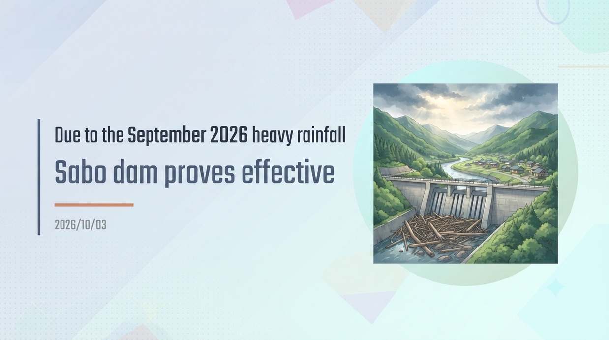
During the heavy rain on September 14, 2026, a sabo dam installed in Taka Town, Hyogo Prefecture, captured approximately 3,000 cubic meters of driftwood and sediment, successfully preventing damage to downstream settlements and public facilities. Hyogo Prefecture is advancing the 5th Mountain Disaster Prevention and Sediment Disaster Countermeasures Plan (Reiwa 8–12), which once again demonstrates the importance of sediment disaster prevention effects through infrastructure development.
- [Key Points of the Event] Intercepted driftwood and sediment in Taka Town, fiercely protecting the downstream settlement
- [In the Field of Disaster Prevention] Structure of the Tadagawa Sabo Dam and Details of Capture Data
- [Weather and Warning Timeline] The Stationary Front and Level 4 Warnings That Brought 171 mm of Continuous Rainfall
- [Changes in the Plan] Structural measures at 1,050 locations triggered by the 2009 typhoon disaster
- [Sediment Disaster Prevention Act and Warning Areas] Designation of Yellow and Red Zones and Non-Structural Measures
- [Wide-Area and Precedent-Setting Effects] The Cost-Effectiveness of Sabo Investment as Seen in Past Events Such as the July 2018 Heavy Rain
- [Future Outlook and Key Focus Areas] Launch of the 5th Plan and Deepening Focus Toward Basin-Wide Flood Control and Residential Induction Area Conservation
[Key Points of the Event] Intercepted driftwood and sediment in Taka Town, fiercely protecting the downstream settlement
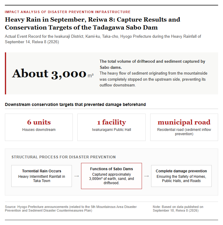
On September 18, 2026, Hyogo Prefecture announced that erosion control (sabo) facilities installed across the prefecture demonstrated remarkable disaster prevention effects during the heavy rainfall that occurred on September 14 of the same year. Particularly significant results were confirmed at the Tadayama Sabo Dam, located in the Iwatsugami district of Kami-ku, Taka Town, Taka District, Hyogo Prefecture. On that day, heavy rain fell intermittently, primarily centered in the Harima region, causing massive amounts of driftwood and sediment to wash down from the mountain slopes along with torrential currents. However, the sabo dam constructed along the mountain stream captured this debris with extreme precision, halting the downstream flow of sediment on the upstream side of the structure. As a result, sediment inflow and damage to six residential homes located downstream—along with the Iwatsugami Public Hall, a vital community hub, and local municipal roads—were completely prevented. This serves as a quintessential example of how proactive hard infrastructure measures can function as a bulwark protecting residents’ lives, property, and community foundations against increasingly severe weather disasters. It is drawing attention as a concrete achievement that boosts the community’s sense of security.
The following image shows the conditions around the sabo dam and the settlement targeted for preservation before and after the disaster.
[In the Field of Disaster Prevention] Structure of the Tadagawa Sabo Dam and Details of Capture Data
The Tadagawa Sabo Dam, which proved its effectiveness, is a facility completed in fiscal 2019 as part of the erosion control (sabo) projects promoted by Hyogo Prefecture. According to a survey by the Sabo Division of the Hyogo Prefectural Government’s Public Works Department, continuous rainfall reached 171 mm from 13:00 on September 14 to 14:00 on September 15, 2026, and torrential rainfall with a maximum hourly precipitation of 63 mm was recorded between 18:00 and 19:00 on the 14th. This torrential downpour triggered a slope failure, sending an estimated 3,000 cubic meters of massive sediment and driftwood rushing down the mountain stream. However, the openings and permeable structures of the Tadagawa Sabo Dam firmly intercepted the driftwood and giant boulders. It is estimated that without this sabo dam, the debris flow, accelerated by the steep slopes characteristic of mountainous areas, would have directly hit the downstream settlement, causing catastrophic damage such as the washout, total or partial destruction of houses, damage to the public hall, and the blockage of road networks. Numerical data also supports the fact that the pre-invested construction budget and engineering work immediately generated damage-mitigation effects exceeding their costs in an actual disaster situation.
[Weather and Warning Timeline] The Stationary Front and Level 4 Warnings That Brought 171 mm of Continuous Rainfall
The meteorological factor that triggered this sediment runoff was an extreme destabilization of the atmosphere caused by moist air flowing toward a stationary front lingering near the Japanese archipelago. According to an announcement by the Kobe Local Meteorological Observatory, linear rain clouds developed mainly in the Harima region within Hyogo Prefecture from September 14 to 15, 2026, resulting in heavy rainfall that rapidly swelled rivers and loosened mountain slopes in a short period of time. With the situation becoming increasingly tense, Hyogo Prefecture and the Meteorological Observatory issued Sediment Disaster Danger Warnings equivalent to Evacuation Level 4 for two cities and one town—Himeji City, Tatsuno City, and Taka Town—strongly urging evacuation orders and early evacuation actions. Sediment disasters frequently occur shortly after rainfall begins, and there is a risk that evacuation actions themselves can become extremely difficult during the night or when visibility is poor. Alongside the prompt disaster prevention weather information issued by local governments, the fact that sabo (sediment control) facilities designed to physically block flowing sediment were operational at the site was a crucial factor that led to averting disaster by a hair’s breadth.
The History and Institutional Background of Mountain Disaster Prevention and Sediment-Related Disaster Countermeasures in Hyogo Prefecture
[Changes in the Plan] Structural measures at 1,050 locations triggered by the 2009 typhoon disaster
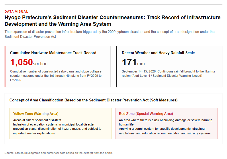
Behind the acceleration of sabo (erosion control) infrastructure development in Hyogo Prefecture lie the lessons learned from a succession of devastating wind and flood disasters in the past. Particularly in the wake of the 2009 Typhoon No. 9 disaster, which caused fatalities and missing persons, the prefecture formulated the “Mountainous Disaster Prevention and Sediment Disaster Countermeasures Plan” and has worked to systematically expand disaster prevention infrastructure in phases. Across the 1st through 4th plans spanning from fiscal 2009 to fiscal 2025, the prefecture has engaged in the construction of sabo dams and steep slope collapse prevention facilities at a cumulative total of 1,050 locations, focusing on measures to protect residential areas and other sites. When the Tamba City torrential rains of 2014 and the July 2018 torrential rains occurred, the prefecture proactively leveraged national budgetary measures such as the “Emergency Measures for Disaster Prevention, Mitigation, and National Resilience” and the “Five-Year Acceleration Measures,” executing agile operations to develop targeted sites ahead of schedule. This longstanding, planned budgetary allocation and the cumulative execution of construction based on clear priorities have directly translated into the major achievement of zero damage in Taka Town during the torrential rains of September 2026.
[Sediment Disaster Prevention Act and Warning Areas] Designation of Yellow and Red Zones and Non-Structural Measures
An important measure that pairs with hard infrastructure improvements such as sabo facilities is soft measures based on the Sediment Disaster Prevention Act (official name: Act on the Promotion of Measures for Sediment Disaster Prevention in Sediment Disaster Caution Areas, etc.). Under this act, areas at risk of sediment disasters are designated as Sediment Disaster Caution Areas (commonly known as yellow zones), making it mandatory to include evacuation systems in municipal local disaster management plans, raise awareness through hazard maps, and explain important matters during real estate transactions. Furthermore, areas where buildings are likely to be damaged or where there is a risk of severe danger to human life are designated as Sediment Disaster Special Caution Areas (commonly known as red zones), where a system requiring prefectural governor permission for specific development activities, structural regulations for buildings, and relocation recommendation and subsidy systems for hazardous houses are applied. In Hyogo Prefecture, residential houses and facilities for vulnerable people within red zones are prioritized as conservation targets and incorporated into development plans, with area designation based on legal systems and structural maintenance working together to enhance the region’s disaster prevention capabilities.
The following schematic diagram shows the concept of area classification based on the Act.
Future Disaster Prevention Strategies and Nationwide Expansion into Flood Control and Sediment Control
[Wide-Area and Precedent-Setting Effects] The Cost-Effectiveness of Sabo Investment as Seen in Past Events Such as the July 2018 Heavy Rain
The disaster prevention effects provided by sabo dams are not limited to Hyogo Prefecture, but have been objectively proven at disaster sites nationwide. For example, according to estimates by the Ministry of Land, Infrastructure, Transport and Tourism regarding sabo projects in Hiroshima Prefecture during the July 2018 heavy rain, compared to the approximately 30 billion yen spent so far on facility construction and maintenance, the estimated reduction in damages—achieved by sabo dams capturing debris flows and driftwood—amounts to approximately 100 billion yen. The cost-benefit ratio (B/C) of disaster prevention and mitigation relative to construction investment is extremely high, and the reduction of social losses and recovery costs made possible by the presence of these facilities is immense. In today’s world, where localized and increasingly severe heavy rains have become the norm, the development of sabo facilities as public works is positioned not merely as construction work, but as an indispensable risk management initiative to protect the lives of local residents and prevent the financial collapse of local governments. The case of Taka Town, Hyogo Prefecture, similarly demonstrates a high return on investment that aligns with past regional data.
[Future Outlook and Key Focus Areas] Launch of the 5th Plan and Deepening Focus Toward Basin-Wide Flood Control and Residential Induction Area Conservation
Hyogo Prefecture has newly launched the “5th Mountainous Disaster Prevention and Sediment Disaster Countermeasures Plan,” covering a five-year period from fiscal 2026 to fiscal 2030 (Reiwa 8 to Reiwa 12). In the 5th plan, while continuing to prioritize infrastructure development in traditionally high-urgency special warning zones, new perspectives anticipating a depopulating society have been introduced. Efforts such as ensuring the safety of residential promotion areas—where habitation is expected to be maintained into the future—and protecting “nariwai” (local livelihoods), which form the region’s unique industrial and agricultural foundations, from sediment disasters have been added as priority measures. Furthermore, coordination is being promoted with the “River Basin Flood Control Project” advanced by the Ministry of Land, Infrastructure, Transport and Tourism, as well as with sabo maintenance projects linked to urban planning. In response to increasing rainfall due to climate change, a comprehensive flood control and sabo strategy that integrates not only physical infrastructure development but also residential guidance and disaster-resilient urban planning is in demand, and Hyogo Prefecture’s cutting-edge initiatives are expected to progress as a model case for sediment disaster countermeasures by local governments across Japan.
Reference Page
- [Hyogo Prefecture / Public Works Department, Sabo Division] https://web.pref.hyogo.lg.jp/org/sabo/index.html
- [Hyogo Prefecture / 5th Mountainous Disaster and Sediment Disaster Countermeasures Plan (FY2026–2030)] https://web.pref.hyogo.lg.jp/ks15/wd17_000000030.html
- [Ministry of Land, Infrastructure, Transport and Tourism / Regarding the Progress of River Basin Flood Control Initiatives for FY2025] https://www.mlit.go.jp/report/press/mizukokudo05_hh_000273.html
【#HyogoPrefecture #SaboDam #SedimentDisaster #DisasterPreventionPlan #September2026HeavyRainfall #RiverBasinFloodControl #TakaTown】

コメント